
Size of this preview:
800 × 127 pixels. Other resolution:
933 × 148 pixels.
Original file (933 × 148 pixels, file size: 19 KB, MIME type: image/png)
| This is a file from the
Wikimedia Commons. Information from its
description page there is shown below. Commons is a freely licensed media file repository. You can help. |
Summary
| Description |
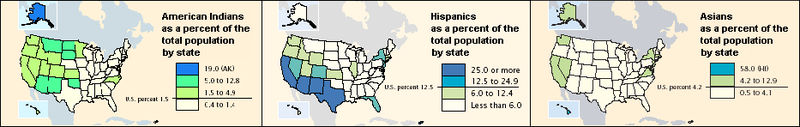
English: Census maps of the American West |
| Source | US Census Bureau Briefs |
| Author | United States Census Bureau |
Licensing
This image or file is a work of a
United States Census Bureau employee, taken or made as part of that person's official duties. As a
work of the
U.S. federal government, the image is in the
public domain.
|
 |
Original upload log
The original description page was
here. All following user names refer to en.wikipedia.
| Date/Time | Dimensions | User | Comment |
|---|---|---|---|
| 2004-10-29 16:06 | 933×148× (19197 bytes) | CPret | Census maps of the American West |
File history
Click on a date/time to view the file as it appeared at that time.
| Date/Time | Thumbnail | Dimensions | User | Comment | |
|---|---|---|---|---|---|
| current | 20:37, 27 March 2016 |
| 933 × 148 (19 KB) | Kingofthedead | Transferred from en.wikipedia |
File usage
The following pages on the English Wikipedia use this file (pages on other projects are not listed):