No higher resolution available.
Allegheny_River_Lock_and_Dam_No.4.jpg (720 × 480 pixels, file size: 132 KB, MIME type: image/jpeg)
| This is a file from the
Wikimedia Commons. Information from its
description page there is shown below. Commons is a freely licensed media file repository. You can help. |
|
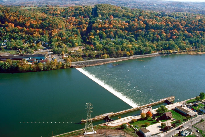
This is an image of a place or building that is listed on the
National Register of Historic Places in the
United States of America. Its reference number is
398. |
| Description |
English: Lock and Dam Number 4 on the Allegheny River, Allegheny County, Pennsylvania, United States. Lock and Dam 4 was built from 1920-27, and opened in 1927. |
|||
| Source |
U.S. Army Corps of Engineers Digital Visual Library Image page Image description page |
|||
| Author | U.S. Army Corps of Engineers | |||
| Permission ( Reusing this file) |
|
| Object location |
| View this and other nearby images on: OpenStreetMap |
|
|---|
File history
Click on a date/time to view the file as it appeared at that time.
| Date/Time | Thumbnail | Dimensions | User | Comment | |
|---|---|---|---|---|---|
| current | 06:31, 7 November 2009 |
| 720 × 480 (132 KB) | Geneisner | {{Information |Description={{en|1=Lock and Dam Number 4 on the Allegheny River, Allegheny County, Pennsylvania, United States. Lock and Dam 4 was built from 1920-27, and opened in 1927.}} |Source=U.S. Army Corps of Engineers Digital Visual Library [http: |
File usage
The following pages on the English Wikipedia use this file (pages on other projects are not listed):
- Allegheny River Lock and Dam No. 4
- Lower Burrell, Pennsylvania
- National Register of Historic Places listings in Allegheny County, Pennsylvania
- National Register of Historic Places listings in Westmoreland County, Pennsylvania
- Natrona, Pennsylvania
- User:Smallbones/PA Gallery
- User talk:Dthomsen8/List PA Test
Global file usage
The following other wikis use this file:
- Usage on ar.wikipedia.org
- Usage on azb.wikipedia.org
- Usage on ca.wikipedia.org
- Usage on ceb.wikipedia.org
- Usage on ce.wikipedia.org
- Usage on ch.wikipedia.org
- Usage on cs.wikipedia.org
- Usage on cy.wikipedia.org
- Usage on de.wikipedia.org
- Usage on eu.wikipedia.org
- Usage on fr.wikipedia.org
- Usage on ht.wikipedia.org
- Usage on it.wikipedia.org
- Usage on lld.wikipedia.org
- Usage on pl.wikipedia.org
- Usage on pt.wikipedia.org
- Usage on simple.wikipedia.org
- Usage on sr.wikipedia.org
- Usage on sv.wikipedia.org
- Usage on tl.wikipedia.org
- Usage on tr.wikipedia.org
- Usage on tt.wikipedia.org
- Usage on uk.wikipedia.org
- Usage on uz.wikipedia.org
- Usage on vi.wikipedia.org
- Usage on vo.wikipedia.org
- Usage on www.wikidata.org
- Usage on zh-min-nan.wikipedia.org