
Size of this preview:
800 × 500 pixels. Other resolutions:
320 × 200 pixels |
640 × 400 pixels |
1,220 × 762 pixels.
Original file (1,220 × 762 pixels, file size: 275 KB, MIME type: image/jpeg)
| This is a file from the
Wikimedia Commons. Information from its
description page there is shown below. Commons is a freely licensed media file repository. You can help. |
| Description |
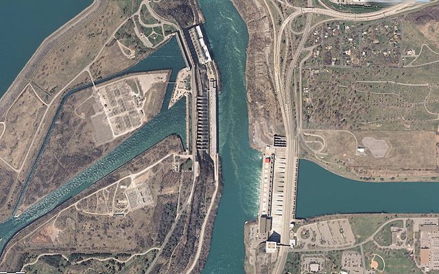
English: Sir Adam Beck Hydroelectric Power Stations (left) and the Robert Moses Niagara Hydroelectric Power Station (right) along the Niagara River. View shows both channels that divert water from the river towards each dam. Scale of 1:9,028. Cropped to remove the National Map bug, and map legend. |
|||
| Date | Unknown date, late 2000's | |||
| Source | USGS National Map, http://viewer.nationalmap.gov/viewer/?p=default&b=base2&x=-8799133.46180887&y=5334036.481491124&l=16&sc=&v= | |||
| Author | USGS | |||
| Permission ( Reusing this file) |
|
File history
Click on a date/time to view the file as it appeared at that time.
| Date/Time | Thumbnail | Dimensions | User | Comment | |
|---|---|---|---|---|---|
| current | 00:21, 10 September 2012 |
| 1,220 × 762 (275 KB) | Oaktree b | {{Information |Description ={{en|1=Sir Adam Beck Hydroelectric Power Stations (left) and the Robert Moses Niagara Hydroelectric Power Station (right) along the Niagara River. View shows both channels that divert water from the river towards each dam... |
File usage
The following pages on the English Wikipedia use this file (pages on other projects are not listed):
Global file usage
The following other wikis use this file:
- Usage on fr.wikipedia.org
- Usage on nl.wikipedia.org
- Usage on uk.wikipedia.org