
Size of this preview:
800 × 525 pixels. Other resolutions:
320 × 210 pixels |
640 × 420 pixels |
1,024 × 672 pixels |
1,280 × 839 pixels |
2,342 × 1,536 pixels.
Original file (2,342 × 1,536 pixels, file size: 806 KB, MIME type: image/jpeg)
| This is a file from the
Wikimedia Commons. Information from its
description page there is shown below. Commons is a freely licensed media file repository. You can help. |
Summary
| Description |
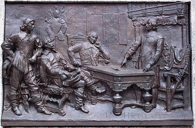
Français : Acte de fondation de Ville-Marie Bas-relief de Louis-Philippe Hébert, Monument à Maisonneuve, Place d'Armes, Montréal. |
| Date | |
| Source |
Photo prise par Jean Gagnon sur place |
| Author | Louis-Philippe Hébert |
| Camera location |
| View this and other nearby images on: OpenStreetMap |
|
|---|
Signature à Meudon de l'acte de fondation de Ville-Marie. Les personnages représentés sont probablement de gauche à droite : le baron Gaston de Renty, Pierre Chevrier, baron de Fancamp, MM Jean-Jacques Olier et Jérôme le Royer de la Dauversière.
Licensing
I, the copyright holder of this work, hereby publish it under the following license:
This file is licensed under the
Creative Commons
Attribution-Share Alike 3.0 Unported license.
- You are free:
- to share – to copy, distribute and transmit the work
- to remix – to adapt the work
- Under the following conditions:
- attribution – You must give appropriate credit, provide a link to the license, and indicate if changes were made. You may do so in any reasonable manner, but not in any way that suggests the licensor endorses you or your use.
- share alike – If you remix, transform, or build upon the material, you must distribute your contributions under the same or compatible license as the original.
File history
Click on a date/time to view the file as it appeared at that time.
| Date/Time | Thumbnail | Dimensions | User | Comment | |
|---|---|---|---|---|---|
| current | 23:33, 23 May 2011 |
| 2,342 × 1,536 (806 KB) | Jeangagnon | Nouvelle prise |
| 17:11, 26 December 2008 |
 | 2,439 × 1,551 (1.32 MB) | Jeangagnon | {{Information |Description= |Source= |Date= |Author= |Permission= |other_versions= }} | |
| 03:35, 24 December 2008 |
 | 967 × 640 (504 KB) | Jeangagnon | {{Information |Description= |Source= |Date= |Author= |Permission= |other_versions= }} | |
| 03:10, 24 December 2008 |
 | 967 × 640 (504 KB) | Jeangagnon | {{Information |Description={{fr|1=Bas-relief de Louis-Philippe Hébert, Monument à Maisonneuve, Place d'Armes, Montréal.}} |Source=From the book: Histoire du Montréal, François Dollier de Casson, Nouvelle édition critique par Marcel Trudel et Marie B |
File usage
The following pages on the English Wikipedia use this file (pages on other projects are not listed):
Global file usage
The following other wikis use this file:
- Usage on de.wikipedia.org
- Usage on fr.wikipedia.org
- Usage on zh.wikipedia.org