Size of this preview:
800 × 489 pixels. Other resolutions:
320 × 196 pixels |
640 × 391 pixels |
1,024 × 626 pixels |
1,280 × 783 pixels |
2,000 × 1,223 pixels.
Original file (2,000 × 1,223 pixels, file size: 2.33 MB, MIME type: image/jpeg)
| This is a file from the
Wikimedia Commons. Information from its
description page there is shown below. Commons is a freely licensed media file repository. You can help. |
.jpg)
Summary
| Description |
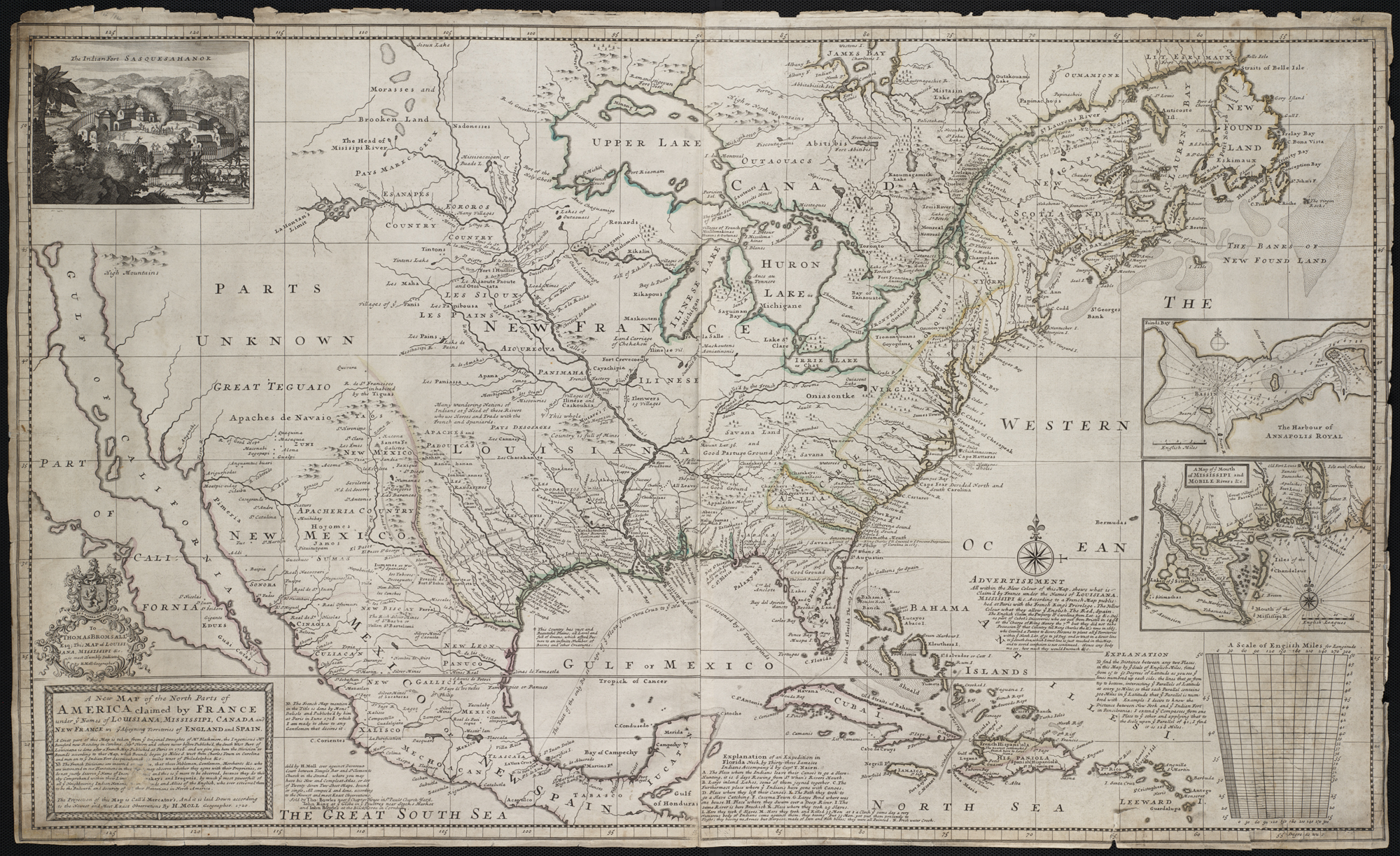
Zoom into this map at maps.bpl.org. Author: Moll, Herman Publisher: Sold by H. Moll Date: [1720] Location: North America Scale: Scale ca. 1:7,000,000 ; Call Number: G3300 1720.M6 In 1720, London geographer and mapmaker, Herman Moll, published this map focusing on France's North American possessions. In a message below the title, he warned his British audience of French encroachment on neighboring English interests in the region and urged them to preserve old friendships with the Iroquois and Cherokees. The depiction of the Southeast was based on recent English surveys, particularly those of Richard Berresford and Capt. Thomas Naime. However, the Southwest, where California is depicted as island, was based on outdated information that was mistakenly accepted by European mapmakers from the mid-17th century until the early 18th century. |
| Date | |
| Source | A new map of the north parts of America claimed by France under ye names of Louisiana[...] |
| Author | http://maps.bpl.org |
Licensing
This file is licensed under the
Creative Commons
Attribution 2.0 Generic license.
- You are free:
- to share – to copy, distribute and transmit the work
- to remix – to adapt the work
- Under the following conditions:
- attribution – You must give appropriate credit, provide a link to the license, and indicate if changes were made. You may do so in any reasonable manner, but not in any way that suggests the licensor endorses you or your use.
| This image, originally posted to Flickr, was reviewed on 21 August 2013 by the administrator or reviewer File Upload Bot (Magnus Manske), who confirmed that it was available on Flickr under the stated license on that date. |
File history
Click on a date/time to view the file as it appeared at that time.
| Date/Time | Thumbnail | Dimensions | User | Comment | |
|---|---|---|---|---|---|
| current | 04:38, 21 August 2013 |
| 2,000 × 1,223 (2.33 MB) | File Upload Bot (Magnus Manske) | Transferred from Flickr by User:tm |
File usage
The following pages on the English Wikipedia use this file (pages on other projects are not listed):
Global file usage
The following other wikis use this file:
- Usage on da.wikipedia.org
- Usage on la.wikipedia.org
- Usage on ms.wikipedia.org
- Usage on ru.wikipedia.org
.jpg)