This is a file from the Wikimedia Commons
From Wikipedia, the free encyclopedia

Original file(6,466 × 4,806 pixels, file size: 21.99 MB, MIME type: image/jpeg)

Summary

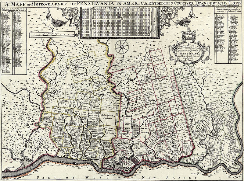
Description A mapp of ye improved part of Pensilvania in America, divided into countyes townships and lotts, Surveyed by Thomas Holme for William Penn Esq.. This copy sold by P Lea at Atlas and Hercules in Cheapside.
Date
Source
This map is available from the United States Library of Congress's Geography & Map Division
under the digital ID g3820.ct004135.
This tag does not indicate the copyright status of the attached work. A normal copyright tag is still required. See Commons:Licensing.

العربية  беларуская (тарашкевіца)  বাংলা  čeština  Deutsch  English  español  فارسی  suomi  français  galego  עברית  magyar  Bahasa Indonesia  italiano  日本語  lietuvių  македонски  മലയാളം  Nederlands  polski  português  português do Brasil  română  русский  sicilianu  slovenčina  slovenščina  Türkçe  українська  简体中文  繁體中文  +/−

Author Thomas Holme
Permission
( Reusing this file)
This is a faithful photographic reproduction of a two-dimensional, public domain work of art. The work of art itself is in the public domain for the following reason:
Public domain

This work is in the public domain in its country of origin and other countries and areas where the copyright term is the author's life plus 100 years or fewer.


You must also include a United States public domain tag to indicate why this work is in the public domain in the United States.
The official position taken by the Wikimedia Foundation is that "faithful reproductions of two-dimensional public domain works of art are public domain".
This photographic reproduction is therefore also considered to be in the public domain in the United States. In other jurisdictions, re-use of this content may be restricted; see Reuse of PD-Art photographs for details.
Other versions
image extraction process
This file has been extracted from another file
: A mapp of ye improved part of Pensilvania in America, divided into countyes townships and lotts.png
original file
new file This image is a JPEG version of the original PNG image at File: A mapp of ye improved part of Pensilvania in America, divided into countyes townships and lotts.png.

Generally, this JPEG version should be used when displaying the file from Commons, in order to reduce the file size of thumbnail images. However, any edits to the image should be based on the original PNG version in order to prevent generation loss, and both versions should be updated. Do not make edits based on this version.  See here for more information.

Unmodified JPEG version  A mapp of ye improved part of Pensilvania in America, divided into countyes townships and lotts.jpg
This is a retouched picture, which means that it has been digitally altered from its original version. Modifications: Cropped, curves. The original can be viewed here: A mapp of ye improved part of Pensilvania in America, divided into countyes townships and lotts.png .

Information

Captions

Add a one-line explanation of what this file represents

Items portrayed in this file

depicts

image/jpeg

a6fa678faf051d34343112c32f5b9bc5207d9309

23,054,819 byte

4,806 pixel

6,466 pixel

File history

Click on a date/time to view the file as it appeared at that time.

Date/TimeThumbnailDimensionsUserComment
current 10:36, 29 July 2015 Thumbnail for version as of 10:36, 29 July 20156,466 × 4,806 (21.99 MB)Storkk== {{int:filedesc}} == {{Information |Description=A mapp of ye improved part of Pensilvania in America, divided into countyes townships and lotts, Surveyed by Thomas Holmes for [[:en:William Penn|William Penn...
The following pages on the English Wikipedia use this file (pages on other projects are not listed):

Global file usage

The following other wikis use this file: