
Size of this preview:
456 × 600 pixels. Other resolutions:
182 × 240 pixels |
365 × 480 pixels |
584 × 768 pixels |
779 × 1,024 pixels |
1,557 × 2,048 pixels |
5,670 × 7,456 pixels.
Original file (5,670 × 7,456 pixels, file size: 16.53 MB, MIME type: image/jpeg)
| This is a file from the
Wikimedia Commons. Information from its
description page there is shown below. Commons is a freely licensed media file repository. You can help. |
Summary
| Description |
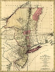
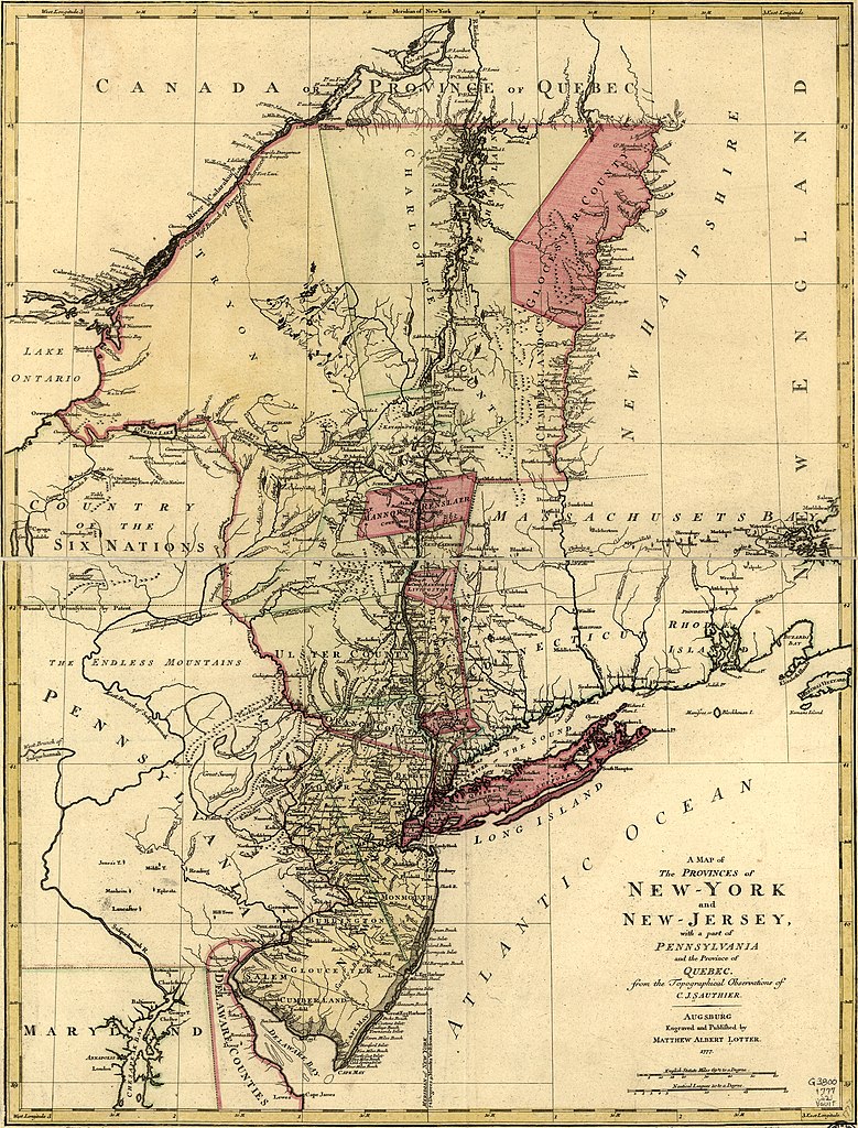
English: Scale ca. 1:1,040,000. Hand colored. LC copy mounted on cloth and paper backing. Prime meridian: New York. Relief shown pictorially. Shows administrative divisions in New York and New Jersey. LC Maps of North America, 1750-1789, 1048 Available also through the Library of Congress Web site as a raster image. Vault AACR2 |
||
| Title | A Map of the Provinces of New York and New Jersey, with a part of Pennsylvania and the Province of Quebec. | ||
| Shelf ID | G3800 1777 .S21 | ||
| Date | |||
| Source | https://www.loc.gov/item/74692641/ | ||
| Author | Sauthier, Claude Joseph; Lotter, Matthäus Albrecht | ||
| Permission ( Reusing this file) |
|
||
| Other versions | |||
| Location | United States · New Jersey · Northeastern States · Québec · New York · New York (State) | ||
| Part of | Military Battles And Campaigns · American Memory · Catalog · Geography And Map Division · American Revolution And Its Era: Maps And Charts Of North America And The West Indies, 1750-1789 | ||
| Subject | United States · New Jersey · Northeastern States · Maps · Early Works To 1800 · Administrative And Political Divisions · New York (State) · Québec (Province) | ||
| Notes | Cropped from .tif |


.jpg)
Licensing
|
This is a faithful photographic reproduction of a two-dimensional,
public domain work of art. The work of art itself is in the public domain for the following reason:
The official position taken by the Wikimedia Foundation is that "faithful reproductions of two-dimensional public domain works of art are public domain".
This photographic reproduction is therefore also considered to be in the public domain in the United States. In other jurisdictions, re-use of this content may be restricted; see Reuse of PD-Art photographs for details. | ||||
File history
Click on a date/time to view the file as it appeared at that time.
| Date/Time | Thumbnail | Dimensions | User | Comment | |
|---|---|---|---|---|---|
| current | 13:32, 29 March 2020 |
| 5,670 × 7,456 (16.53 MB) | Zeete | Uploaded a work by Claude Joseph Sauthier from https://www.loc.gov/item/74692641/ with UploadWizard |
File usage
The following pages on the English Wikipedia use this file (pages on other projects are not listed):
Global file usage
The following other wikis use this file:
- Usage on id.wikipedia.org
- Usage on ml.wikipedia.org
- Usage on www.wikidata.org
.jpg)