
Size of this preview:
800 × 532 pixels. Other resolutions:
320 × 213 pixels |
640 × 426 pixels |
1,024 × 681 pixels |
1,280 × 852 pixels |
2,560 × 1,703 pixels |
4,256 × 2,832 pixels.
Original file (4,256 × 2,832 pixels, file size: 13.38 MB, MIME type: image/jpeg)
| This is a file from the
Wikimedia Commons. Information from its
description page there is shown below. Commons is a freely licensed media file repository. You can help. |
Summary
| Description |
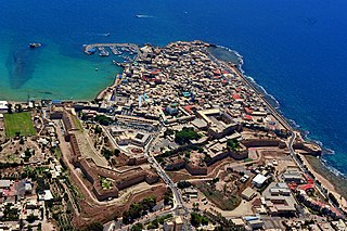
עברית: המצודה בעכו נבנתה בימי הטורקים על בסיסה של המצודה ה
הוספיטלרית בצפונה של העיר העתיקה. המצודה הייתה חלק מן המבנה ההגנתי של עכו, וצידה הצפוני שולב בחומה הצפונית ובמגדל השמירה בורג' אל חזינה. המצודה בנויה סביב שתי חצרות מלבניות, אורכה ממזרח למערב הוא כ-170 מטר ורוחבה כמאה מטרים. במהלך
המאה ה-20 שימשה המצודה כ
בית כלא, ובזמן
המנדט הבריטי שימשה גם להוצאה להורג של
עולי הגרדום. ב-
4 במאי
1947 נערך אחד ממבצעי ה
אצ"ל הנועזים,
פריצת כלא עכו, שבמסגרתו פרצו חברי האצ"ל אל המצודה, ושחררו רבים מן הכלואים בה. לאחר קום המדינה שימש המקום כ
בית חולים פסיכיאטרי.
|
||
| Date | |||
| Source | Own work | ||
| Author | AVRAHAM GRAICER |
| Camera location |
| View this and other nearby images on: OpenStreetMap |
|
|---|
Licensing
I, the copyright holder of this work, hereby publish it under the following license:
This file is licensed under the
Creative Commons
Attribution-Share Alike 4.0 International license.
- You are free:
- to share – to copy, distribute and transmit the work
- to remix – to adapt the work
- Under the following conditions:
- attribution – You must give appropriate credit, provide a link to the license, and indicate if changes were made. You may do so in any reasonable manner, but not in any way that suggests the licensor endorses you or your use.
- share alike – If you remix, transform, or build upon the material, you must distribute your contributions under the same or compatible license as the original.

|
This image was uploaded as part of
Wiki Loves Monuments 2015.
|
 |
File history
Click on a date/time to view the file as it appeared at that time.
| Date/Time | Thumbnail | Dimensions | User | Comment | |
|---|---|---|---|---|---|
| current | 13:18, 10 October 2015 |
| 4,256 × 2,832 (13.38 MB) | AVRAMGR | User created page with UploadWizard |
File usage
The following pages on the English Wikipedia use this file (pages on other projects are not listed):
Global file usage
The following other wikis use this file:
- Usage on ckb.wikipedia.org
- Usage on fr.wikipedia.org
- Usage on it.wikipedia.org
- Usage on ko.wikipedia.org
- Usage on ta.wikipedia.org