Size of this preview:
800 × 489 pixels. Other resolutions:
320 × 196 pixels |
640 × 391 pixels |
1,024 × 626 pixels |
1,280 × 783 pixels |
2,560 × 1,566 pixels |
3,628 × 2,219 pixels.
Original file (3,628 × 2,219 pixels, file size: 2.31 MB, MIME type: image/jpeg)
| This is a file from the
Wikimedia Commons. Information from its
description page there is shown below. Commons is a freely licensed media file repository. You can help. |
Summary
| Description |
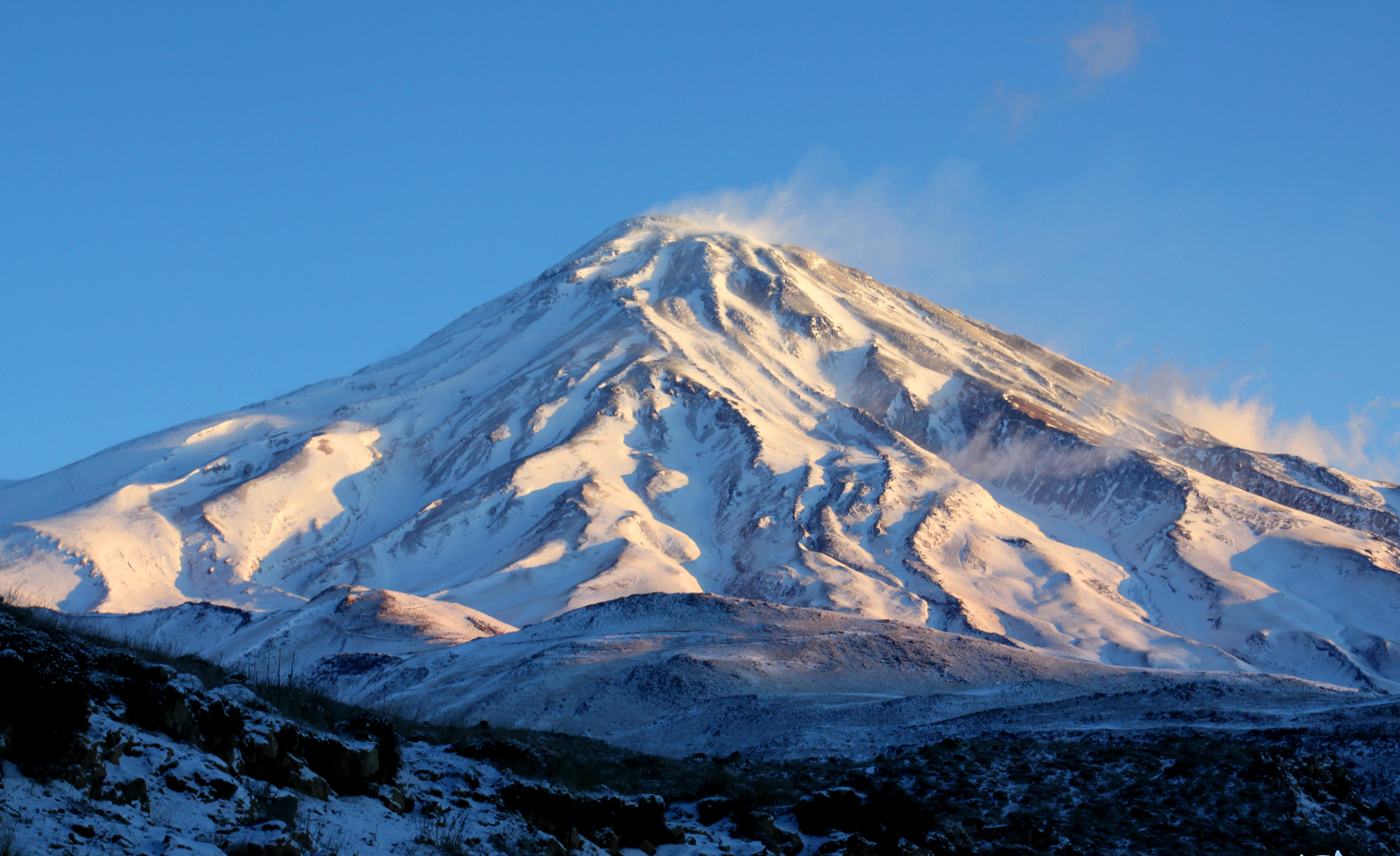
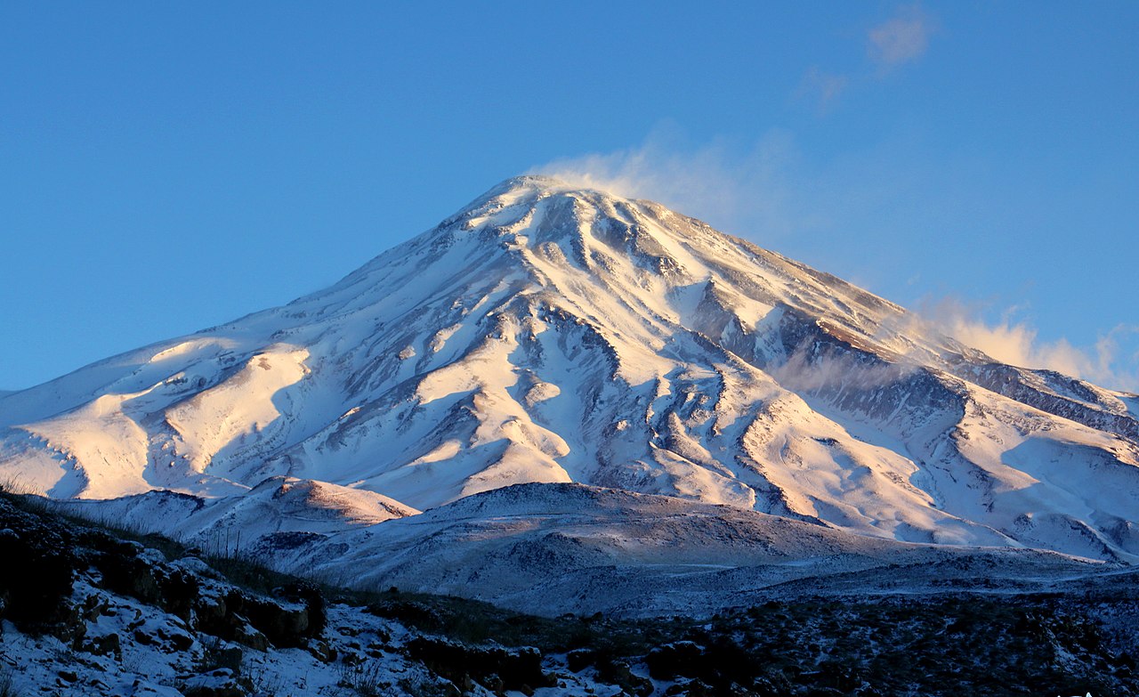
العربية: جبل دماوند، من الجهة الجنوبية، محافظة مازندران، إيران، التقطت الصورة في 2 يناير 2010، تصوير صفا دانشور , The south side - Mazandaran Province, Iran - January 2, 2010 - Photo by: Safa Daneshvar - Thanks to Mr. Reza Ziari |
| Date |
|
| Source |
Own work
|
| Author |
Safa.daneshvar
|
English: Damavand Mountain, The south side - Mazandaran Province, Iran - January 2, 2010 - Photo by: Safa Daneshvar - Thanks to Mr. Reza Ziari
فارسی: کوه دماوند - جبهه جنوبی - دی ماه ۱۳۹۸ - عکس از صفا دانشور - با تشکر از آقای رضا زیاری
|date=2020-01-02 07:21:18 |source=Own work |author= Safa.daneshvar |permission= |other versions= }}
| Camera location |
| View this and other nearby images on: OpenStreetMap |
|
|---|
So many thanks to: Mr. Stafford Francis Tyrrell, Mr. Mark Francis MCinerney, Mr. Reza Ziari, Mr. Shahrzad, Mr. Jafar Hosseinpour, Mr. Mohammad Khamseh, Mr. Kamal, and all others. Thank you to Canon, Scarpa, Mammut, Under Armour.
Licensing
I, the copyright holder of this work, hereby publish it under the following license:
This file is licensed under the
Creative Commons
Attribution-Share Alike 4.0 International license.
- You are free:
- to share – to copy, distribute and transmit the work
- to remix – to adapt the work
- Under the following conditions:
- attribution – You must give appropriate credit, provide a link to the license, and indicate if changes were made. You may do so in any reasonable manner, but not in any way that suggests the licensor endorses you or your use.
- share alike – If you remix, transform, or build upon the material, you must distribute your contributions under the same or compatible license as the original.
File history
Click on a date/time to view the file as it appeared at that time.
| Date/Time | Thumbnail | Dimensions | User | Comment | |
|---|---|---|---|---|---|
| current | 23:28, 8 July 2020 |
| 3,628 × 2,219 (2.31 MB) | Lexy iris | Cropped 9 % horizontally, 11 % vertically using CropTool with precise mode. |
| 12:02, 11 January 2020 |
 | 4,000 × 2,500 (2.67 MB) | Safa.daneshvar | User created page with UploadWizard |
File usage
The following pages on the English Wikipedia use this file (pages on other projects are not listed):
Global file usage
The following other wikis use this file:
- Usage on ar.wikipedia.org
- Usage on arz.wikipedia.org
- Usage on ast.wikipedia.org
- Usage on bg.wikipedia.org
- Usage on bn.wikipedia.org
- Usage on ca.wikipedia.org
- Usage on csb.wikipedia.org
- Usage on cy.wikipedia.org
- Usage on diq.wikipedia.org
- Usage on el.wikipedia.org
- Usage on en.wikivoyage.org
- Usage on es.wikipedia.org
- Usage on eu.wikipedia.org
- Usage on fa.wikipedia.org
- استان مازندران
- بابل (مازندران)
- کاخ شاپور
- آمل
- نوشهر
- ساری
- قائمشهر
- شهرستان قائمشهر
- جواهرده
- بابلسر
- سورک
- شهرستان بابل
- شهرستان آمل
- نکا
- بهشهر
- تنکابن
- شهرستان بابلسر
- دماوند
- شهرستان چالوس
- شهرستان بهشهر
- شهرستان نور
- رامسر
- شهرستان تنکابن
- محمودآباد
- شهرستان محمودآباد
- شهرستان ساری
- گرجیمحله
- جویبار (مازندران)
- کلاردشت
- شهرستان کلاردشت
- آلاشت
- عباسآباد (مازندران)
- پل ورسک
- شیرگاه
- علمکوه
View more global usage of this file.