No higher resolution available.
6438_2155meander.jpg (723 × 535 pixels, file size: 61 KB, MIME type: image/jpeg)
| This is a file from the
Wikimedia Commons. Information from its
description page there is shown below. Commons is a freely licensed media file repository. You can help. |
Summary
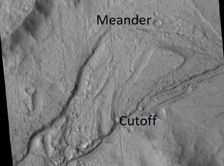
| Description |
English: As streams develop wide meanders may appear in the shape of big loops. As it ages, a cutoff or shortcut will develop. This image shows both. Having a meander and cutoff means the stream flowed for a while--it was not just a short term event. This image was taken from the surface of Mars by the HiRISE camera on board the Mars Reconnaissance Orbiter. The image was named HiRISE picture of the day for August 31, 2021. |
| Date | |
| Source | https://www.uahirise.org/ESP_064038_2155 |
| Author | Jim Secosky selected pictures from NASA files. The credit should read NASA/JPL-Caltech/UArizona. |
| Location on Mars | View this and other nearby images on: Google Maps |
|
|---|
Licensing
| This file is in the public domain in the United States because it was solely created by NASA. NASA copyright policy states that "NASA material is not protected by copyright unless noted". (See Template:PD-USGov, NASA copyright policy page or JPL Image Use Policy.) | ||
 |
Warnings:
|
File history
Click on a date/time to view the file as it appeared at that time.
| Date/Time | Thumbnail | Dimensions | User | Comment | |
|---|---|---|---|---|---|
| current | 21:13, 28 December 2023 |
| 723 × 535 (61 KB) | Jimmarsmars | Uploaded a work by Jim Secosky selected pictures from NASA files. The credit should read NASA/JPL-Caltech/UArizona. from https://www.uahirise.org/ESP_064038_2155 with UploadWizard |
File usage
The following pages on the English Wikipedia use this file (pages on other projects are not listed):