
Size of this PNG preview of this SVG file:
800 × 474 pixels. Other resolutions:
320 × 190 pixels |
640 × 380 pixels |
1,024 × 607 pixels |
1,280 × 759 pixels |
2,560 × 1,518 pixels |
1,000 × 593 pixels.
Original file (SVG file, nominally 1,000 × 593 pixels, file size: 53 KB)
| This is a file from the
Wikimedia Commons. Information from its
description page there is shown below. Commons is a freely licensed media file repository. You can help. |
Summary
| Description |
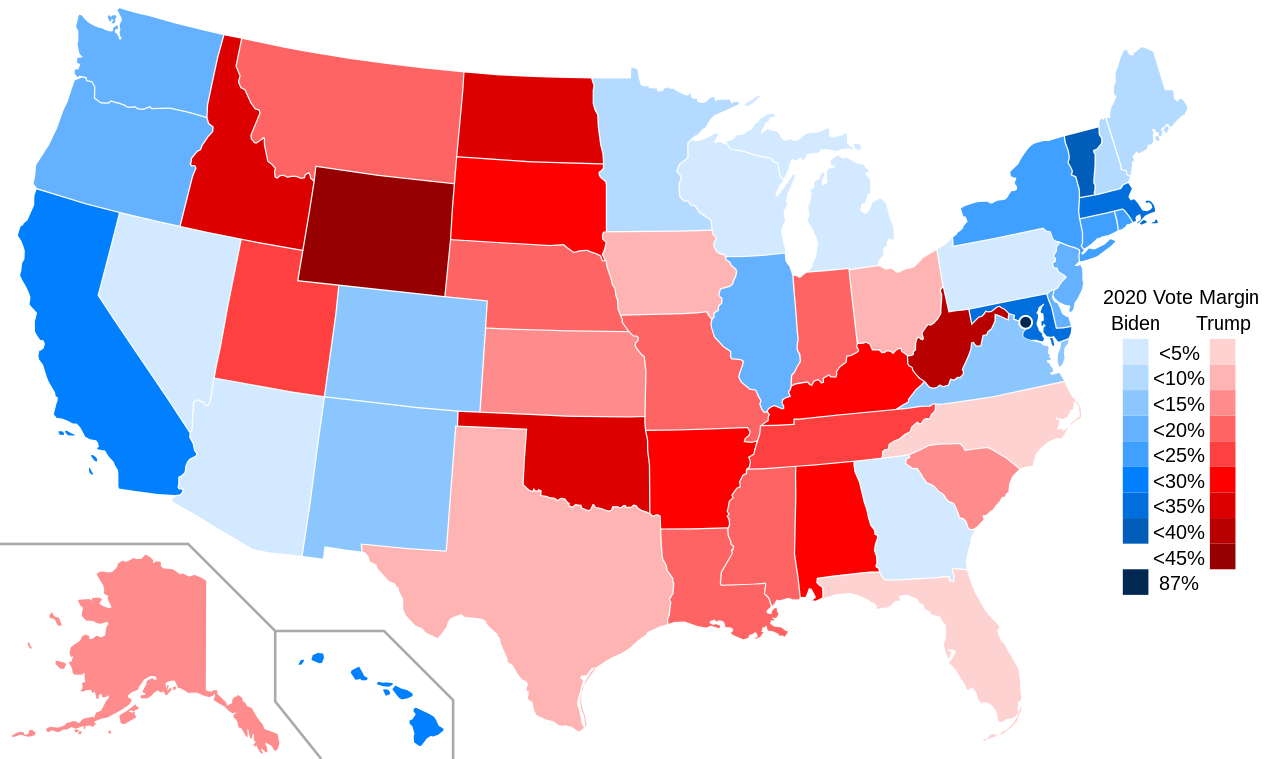
English: A map of states by margin of victory in the 2020 U.S. presidential election. States in red voted for Trump, states in blue voted for Biden. Darker shades indicate larger margins of victory. |
| Date | |
| Source | File:Blank_US_Map_(states_only).svg |
| Author | Crossover1370, based on map by User:Theshibboleth |
.svg)
Licensing
I, the copyright holder of this work, hereby publish it under the following license:
This file is licensed under the
Creative Commons
Attribution-Share Alike 4.0 International license.
- You are free:
- to share – to copy, distribute and transmit the work
- to remix – to adapt the work
- Under the following conditions:
- attribution – You must give appropriate credit, provide a link to the license, and indicate if changes were made. You may do so in any reasonable manner, but not in any way that suggests the licensor endorses you or your use.
- share alike – If you remix, transform, or build upon the material, you must distribute your contributions under the same or compatible license as the original.
File history
Click on a date/time to view the file as it appeared at that time.
| Date/Time | Thumbnail | Dimensions | User | Comment | |
|---|---|---|---|---|---|
| current | 04:48, 24 February 2022 |
| 1,000 × 593 (53 KB) | Crossover1370 | minor changes to legend |
| 00:19, 24 February 2022 |
 | 1,000 × 593 (56 KB) | Crossover1370 | change "margin of victory" to "vote margin" - consistent with my county-level map | |
| 18:35, 31 March 2021 |
 | 1,000 × 593 (57 KB) | Crossover1370 | Change title from "2016 US Election Map" to "2020 US Election Map" | |
| 03:58, 31 March 2021 |
 | 1,000 × 593 (57 KB) | Crossover1370 | Uploaded own work with UploadWizard |
File usage
The following pages on the English Wikipedia use this file (pages on other projects are not listed):
Global file usage
The following other wikis use this file:
- Usage on de.wikipedia.org
- Usage on el.wikipedia.org
- Usage on es.wikipedia.org