
Original file (3,298 × 2,473 pixels, file size: 1.79 MB, MIME type: image/jpeg)
| This is a file from the
Wikimedia Commons. Information from its
description page there is shown below. Commons is a freely licensed media file repository. You can help. |
Summary
| Description |
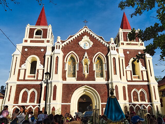
Orig. Flickr desc: St. Augustine Church was built in 1590. Damage incurred during World War II necessitated reconstruction in 1950. The architecture is earthquake Baroque, a Philippine style emphasizing shorter and wider proportions with thick walls in reaction to destructive earthquakes that have periodically struck the Philippines. (The church is commonly known as Bantay Church as it is located in the town of Bantay on the northern border of Vigan City.) Inside the church is housed the image of Our Lady of Charity (locally known as Apo Caridad de Bantay), a statue of the Virgin Mary holding both the Baby Jesus and a gold cross that was discovered in the 17th century by three sea-salt collectors caught in a fierce storm that destroyed their canoes on their way to the sea. The statue was floating on a wooden board inscribed ‘I am the Virgin of Charity’ in Spanish. The shrine is a pilgrimage site. On Google Earth: St. Augustine Church 17°34'52.14"N, 120°23'29.46"E |
| Date | |
| Source | 20180121_Philippines_3508 crop Bantay sRGB |
| Author | Dan Lundberg |
| Camera location |
| View this and other nearby images on: OpenStreetMap |
|
|---|
Licensing
- You are free:
- to share – to copy, distribute and transmit the work
- to remix – to adapt the work
- Under the following conditions:
- attribution – You must give appropriate credit, provide a link to the license, and indicate if changes were made. You may do so in any reasonable manner, but not in any way that suggests the licensor endorses you or your use.
- share alike – If you remix, transform, or build upon the material, you must distribute your contributions under the same or compatible license as the original.
| This image was originally posted to Flickr by Dan Lundberg at https://flickr.com/photos/9508280@N07/41036791101. It was reviewed on 16 July 2020 by FlickreviewR 2 and was confirmed to be licensed under the terms of the cc-by-sa-2.0. |
File history
Click on a date/time to view the file as it appeared at that time.
| Date/Time | Thumbnail | Dimensions | User | Comment | |
|---|---|---|---|---|---|
| current | 03:26, 16 July 2020 |
| 3,298 × 2,473 (1.79 MB) | JWilz12345 | Transferred from Flickr via #flickr2commons |