
Size of this PNG preview of this SVG file:
600 × 600 pixels. Other resolutions:
240 × 240 pixels |
480 × 480 pixels |
768 × 768 pixels |
1,024 × 1,024 pixels |
2,048 × 2,048 pixels |
810 × 810 pixels.
Original file (SVG file, nominally 810 × 810 pixels, file size: 421 KB)
| This is a file from the
Wikimedia Commons. Information from its
description page there is shown below. Commons is a freely licensed media file repository. You can help. |
Summary
| Description |
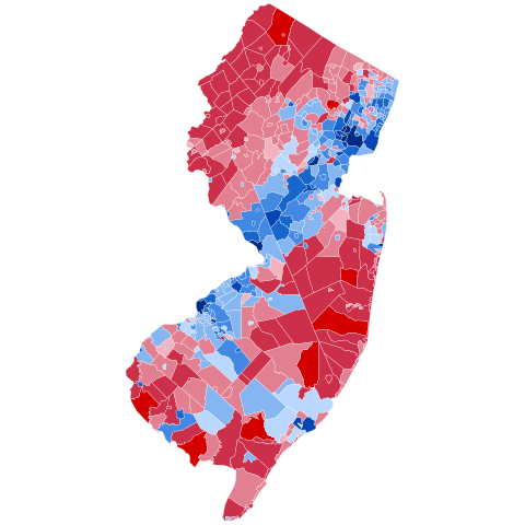
A map of election results for the United States Presidential Election, 2016 in New Jersey.
Hillary Clinton/
Tim Kaine <50%
Hillary Clinton/
Tim Kaine 50–60%
Hillary Clinton/
Tim Kaine 60–70%
Hillary Clinton/
Tim Kaine 70–80%
Hillary Clinton/
Tim Kaine 80–90%
Hillary Clinton/
Tim Kaine 90%
Donald Trump/
Mike Pence >90%
Donald Trump/
Mike Pence 80–90%
Donald Trump/
Mike Pence 70–80%
Donald Trump/
Mike Pence 60–70%
Donald Trump/
Mike Pence 50–60%
Donald Trump/
Mike Pence <50%
tie (
Teterboro only) |
| Date | |
| Source | Map shapefile based on U.S. Census Bureau County Subdivisions, 1990 (modified to match current municipalities), results from New Jersey Division of Elections |
| Author | Mr. Matté (if there is an issue with this image, contact me using this image's Commons talk page, my Commons user talk page, or my English Wikipedia user talk page; I'll know about it a lot faster) |
Licensing
I, the copyright holder of this work, hereby publish it under the following licenses:

|
Permission is granted to copy, distribute and/or modify this document under the terms of the GNU Free Documentation License, Version 1.2 or any later version published by the Free Software Foundation; with no Invariant Sections, no Front-Cover Texts, and no Back-Cover Texts. A copy of the license is included in the section entitled GNU Free Documentation License. |
This file is licensed under the
Creative Commons Attribution-Share Alike
4.0 International,
3.0 Unported,
2.5 Generic,
2.0 Generic and
1.0 Generic license.
- You are free:
- to share – to copy, distribute and transmit the work
- to remix – to adapt the work
- Under the following conditions:
- attribution – You must give appropriate credit, provide a link to the license, and indicate if changes were made. You may do so in any reasonable manner, but not in any way that suggests the licensor endorses you or your use.
- share alike – If you remix, transform, or build upon the material, you must distribute your contributions under the same or compatible license as the original.
You may select the license of your choice.
File history
Click on a date/time to view the file as it appeared at that time.
| Date/Time | Thumbnail | Dimensions | User | Comment | |
|---|---|---|---|---|---|
| current | 01:51, 31 January 2024 |
| 810 × 810 (421 KB) | Putitonamap98 | shapes |
| 18:10, 15 December 2016 |
 | 747 × 1,418 (361 KB) | Mr. Matté | =={{int:filedesc}}== {{Information |Description=A map of election results for the United States Presidential Election, 2016 [[:en:United States presidential election in New Jersey, 2016|in New Jer... |
File usage
The following pages on the English Wikipedia use this file (pages on other projects are not listed):
Global file usage
The following other wikis use this file:
- Usage on fr.wikipedia.org