
Size of this preview:
691 × 599 pixels. Other resolutions:
277 × 240 pixels |
554 × 480 pixels |
886 × 768 pixels |
1,181 × 1,024 pixels |
2,361 × 2,048 pixels |
2,607 × 2,261 pixels.
Original file (2,607 × 2,261 pixels, file size: 1.77 MB, MIME type: image/jpeg)
| This is a file from the
Wikimedia Commons. Information from its
description page there is shown below. Commons is a freely licensed media file repository. You can help. |
Summary
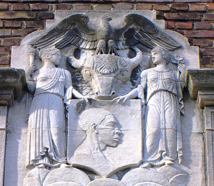
| Description | The Dunbar Apartments is a complex of buildings located on West 149th and West 150th Streets between Frederick Douglass Boulevard/Macombs Place and Adam Clayton Powell Jr. Boulevard in the Harlem neighborhood of Manhattan, New York City. They were built by John D. Rockefeller, Jr. from 1926 to 1928 to provide housing for African Americans, the first project of its kind. The buildings were designed by architect Andrew J. Thomas and were named in honor of the noted African American poet Paul Laurence Dunbar. (Sources: Guide to NYC Landmarks (4th ed.) and AIA Guide to NYC (5th ed.)) |
| Date | |
| Source | Own work |
| Author | Beyond My Ken |
| Camera location | | View this and other nearby images on: OpenStreetMap |
|
|---|
Licensing
I, the copyright holder of this work, hereby publish it under the following licenses:

|
Permission is granted to copy, distribute and/or modify this document under the terms of the GNU Free Documentation License, Version 1.2 or any later version published by the Free Software Foundation; with no Invariant Sections, no Front-Cover Texts, and no Back-Cover Texts. A copy of the license is included in the section entitled GNU Free Documentation License. |
This file is licensed under the
Creative Commons Attribution-Share Alike
4.0 International,
3.0 Unported,
2.5 Generic,
2.0 Generic and
1.0 Generic license.
- You are free:
- to share – to copy, distribute and transmit the work
- to remix – to adapt the work
- Under the following conditions:
- attribution – You must give appropriate credit, provide a link to the license, and indicate if changes were made. You may do so in any reasonable manner, but not in any way that suggests the licensor endorses you or your use.
- share alike – If you remix, transform, or build upon the material, you must distribute your contributions under the same or compatible license as the original.
You may select the license of your choice.
File history
Click on a date/time to view the file as it appeared at that time.
| Date/Time | Thumbnail | Dimensions | User | Comment | |
|---|---|---|---|---|---|
| current | 17:58, 9 April 2014 |
| 2,607 × 2,261 (1.77 MB) | Beyond My Ken | crop in to subject |
| 17:47, 9 April 2014 |
 | 3,456 × 3,096 (3.16 MB) | Beyond My Ken | == {{int:filedesc}} == {{Information |Description= The ''' Dunbar Apartments''' is a complex of buildings located on West 149th and West 150th Streets between Frederick Douglass Boulevard/Macombs Place and Adam Clayton Powell Jr.... |
File usage
The following pages on the English Wikipedia use this file (pages on other projects are not listed):