
Size of this PNG preview of this SVG file:
337 × 600 pixels. Other resolutions:
135 × 240 pixels |
269 × 480 pixels |
431 × 768 pixels |
575 × 1,024 pixels |
1,150 × 2,048 pixels |
455 × 810 pixels.
Original file (SVG file, nominally 455 × 810 pixels, file size: 40 KB)
| This is a file from the
Wikimedia Commons. Information from its
description page there is shown below. Commons is a freely licensed media file repository. You can help. |
| Description |
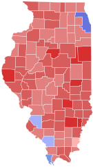
Results of the
United States Senate election in Illinois, 2010 40-50% 50-60% 60-70% 70–80%
Giannoulias 40-50% 50–60% 60–70% |
||
| Date | 27 November 2018 (upload date) | ||
| Source | Own work based on: 2000nationwidecountymapshadedbyvoteshare.svg by Inqvisitor; data from OurCampaigns.com and USElectionAtlas.org | ||
| Author | Ali Zifan, Inqvisitor, Svenskbygderna ( talk) | ||
| Permission ( Reusing this file) |
|
||
| SVG development |
File history
Click on a date/time to view the file as it appeared at that time.
| Date/Time | Thumbnail | Dimensions | User | Comment | |
|---|---|---|---|---|---|
| current | 17:12, 21 April 2024 |
| 455 × 810 (40 KB) | Watchduck | The 455 × 810 files based on File:Illinois county map, cb 500k.svg are the only reasonable choice for this set. |
| 19:20, 18 April 2024 |
 | 810 × 810 (43 KB) | Putitonamap98 | Reverted to version as of 22:13, 16 April 2024 (UTC) aligns with first round results | |
| 10:00, 17 April 2024 |
 | 455 × 810 (40 KB) | Watchduck | cropped version with refined shapes | |
| 08:44, 17 April 2024 |
 | 512 × 925 (41 KB) | Watchduck | Please stop adding useless margins, and instead use the correct syntax in templates. See Category talk:Standardized SVG county maps of US states#Left and right margins. | |
| 22:13, 16 April 2024 |
 | 810 × 810 (43 KB) | Gordfather69 | Reverted to version as of 02:41, 15 January 2024 (UTC) | |
| 10:52, 13 April 2024 |
 | 512 × 925 (41 KB) | Watchduck | Revert to original version. The new version had big margins on the left and right. Feel free to upload a cropped variant of the new version. But please make sure, that all files in the set have the same format. | |
| 02:41, 15 January 2024 |
 | 810 × 810 (43 KB) | Putitonamap98 | shapes | |
| 08:30, 16 December 2022 |
 | 744 × 744 (284 KB) | Putitonamap98 | shapes | |
| 22:37, 27 November 2018 |
 | 512 × 925 (41 KB) | Pharexia | colors | |
| 01:07, 8 November 2010 |
 | 187 × 337 (53 KB) | Gage | update |
File usage
The following pages on the English Wikipedia use this file (pages on other projects are not listed):
Global file usage
The following other wikis use this file:
- Usage on fr.wikipedia.org
- Usage on no.wikipedia.org