PhotosLocation

This is a file from the Wikimedia Commons
From Wikipedia, the free encyclopedia

Original file(3,888 × 2,592 pixels, file size: 3.71 MB, MIME type: image/jpeg)

This is an image of a place or building that is listed on the National Register of Historic Places in the United States of America. Its reference number is 70000452.

Summary

Description
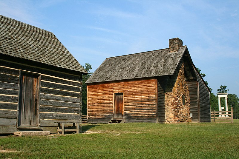
Deutsch: Bennett Place, ein sorgfältig rekonstruierter, historischer Bauernhof in Durham / North Carolina / USA, jener Ort, an dem die Konföderierten (Südstaaten) während des Amerikanischen Bürgerkriegs am 26. April 1865 ihre größte Niederlage erlitten. Anordnung von links nach rechts: Küche, das Bauernhaus und das Denkmal.
English: Bennett Place, a carefully reconstructed historic farm in Durham, North Carolina, the site of the largest surrender of Confederate soldiers during the American Civil War on April 26, 1865. Showing, from left to right, the kitchen, the farmhouse, and the memorial monument.
Français : Bennett Place, une ferme historique scrupuleusement reconstruite à Durham, en Caroline du Nord (États Unis d'Amérique). Durham est le lieu où s'est déroulée la plus large reddition de troupes sudistes de toute la guerre de sécession, le 26 avril 1865. On peut voir, de gauche à droite, les cuisines, la ferme, et le monument.
Date
Source Own work
Author Ildar Sagdejev ( Specious)
Permission
( Reusing this file)
Photo by Ildar Sagdejev | Website | Gallery | Flickr | Portfolio
This photograph is published under the free licenses specified. If you drop me a line about how you're using it, I'd love that.

Find me:

Camera location 36° 01′ 45.24″ N, 78° 58′ 25.38″ W  Heading=247.5°  Kartographer map based on OpenStreetMap.View this and other nearby images on: OpenStreetMap info

Licensing

I, the copyright holder of this work, hereby publish it under the following licenses:
GNU head Permission is granted to copy, distribute and/or modify this document under the terms of the GNU Free Documentation License, Version 1.2 or any later version published by the Free Software Foundation; with no Invariant Sections, no Front-Cover Texts, and no Back-Cover Texts. A copy of the license is included in the section entitled GNU Free Documentation License.
w:en:Creative Commons
attribution share alike
This file is licensed under the Creative Commons Attribution-Share Alike 4.0 International, 3.0 Unported, 2.5 Generic, 2.0 Generic and 1.0 Generic license.
You are free:
  • to share – to copy, distribute and transmit the work
  • to remix – to adapt the work
Under the following conditions:
  • attribution – You must give appropriate credit, provide a link to the license, and indicate if changes were made. You may do so in any reasonable manner, but not in any way that suggests the licensor endorses you or your use.
  • share alike – If you remix, transform, or build upon the material, you must distribute your contributions under the same or compatible license as the original.
You may select the license of your choice.

This image has been assessed using the Quality image guidelines and is considered a Quality image.

العربية  جازايرية  беларуская  беларуская (тарашкевіца)  български  বাংলা  català  čeština  Cymraeg  Deutsch  Schweizer Hochdeutsch  Zazaki  Ελληνικά  English  Esperanto  español  eesti  euskara  فارسی  suomi  français  galego  עברית  हिन्दी  hrvatski  magyar  հայերեն  Bahasa Indonesia  italiano  日本語  Jawa  ქართული  한국어  kurdî  Lëtzebuergesch  lietuvių  македонски  മലയാളം  मराठी  Bahasa Melayu  Nederlands  Norfuk / Pitkern  polski  português  português do Brasil  rumantsch  română  русский  sicilianu  slovenčina  slovenščina  shqip  српски / srpski  svenska  தமிழ்  తెలుగు  ไทย  Tagalog  Türkçe  toki pona  українська  vèneto  Tiếng Việt  中文  中文(简体)  中文(繁體)  +/−

VI seal

This image has been assessed under the valued image criteria and is considered the most valued image on Commons within the scope: Bennett Place. You can see its nomination here.

Annotations
InfoField
This image is annotated: View the annotations at Commons

Information (Geography)

Captions

Add a one-line explanation of what this file represents

Items portrayed in this file

depicts

16 August 2008

36°1'45.235"N, 78°58'25.385"W

heading: 247.5 degree

image/jpeg

13025c9f24f0de527d239691a747e0ae979f365a

3,887,506 byte

2,592 pixel

3,888 pixel

File history

Click on a date/time to view the file as it appeared at that time.

Date/TimeThumbnailDimensionsUserComment
current 06:14, 14 May 2009 Thumbnail for version as of 06:14, 14 May 20093,888 × 2,592 (3.71 MB)Speciousadjusted levels
18:35, 16 August 2008 Thumbnail for version as of 18:35, 16 August 20083,888 × 2,592 (3.9 MB)Specious{{Information |Description={{en| Bennett Place in Durham, North Carolina.}} |Source=Own work |Author=Ildar Sagdejev ( Specious) |Date=2008-08-16 |Permission={{User:Specious/Ref}} |other_vers

Global file usage

Metadata