
Size of this preview:
800 × 366 pixels. Other resolutions:
320 × 146 pixels |
640 × 293 pixels |
1,024 × 468 pixels |
1,280 × 585 pixels |
2,560 × 1,171 pixels |
8,267 × 3,780 pixels.
Original file (8,267 × 3,780 pixels, file size: 20.98 MB, MIME type: image/jpeg)
| This is a file from the
Wikimedia Commons. Information from its
description page there is shown below. Commons is a freely licensed media file repository. You can help. |
Summary
| Description |
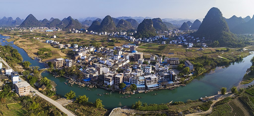
English: Panoramic photograph of
Yangshuo County, near the city of
Guilin,
Guangxi province, China. The photograph was taken from the air using a
drone.
Español: Vista panorámica de la aldea de Yulong en el condado
Yangshuo, cerca de la ciudad de
Guilin, región autónoma
Zhuang de Guangxi, China. A la izquierda se ve el puente Yulong sobre el
río Yulong, construido durante la
dinastía Ming. Desde este lugar comienzan las excursiones turísticas por el río en balsas de bambú. En el fondo, las colinas de la zona de amortiguación
Karst de China meridional, declarado
Patrimonio de la Humanidad en 2007. Esta foto se tomó desde el aire con un
dron.
Русский: Панорамный вид посёлка Юйлунцунь, уезд
Яншо,
Гуанси-Чжуанский автономный район,
КНР. Слева по центру виден мост Юйлунцяо через реку Юйлунхэ, построенный во времена
династии Мин; отсюда начинаются туристические путешествия на
бамбуковом
плоту вниз по реке. Холмы за посёлком —
карстовые
останцы буферной зоны
Южно-Китайского карста, являющегося объектом
Всемирного наследия ЮНЕСКО. Фотография сделана с
БПЛА в декабре 2016 года.
Українська: Панорамний вид селища Юйлунцунь, повіт Яншо, поблизу міста
Ґуйлінь,
Гуансі-Чжуанський автономний район, КНР. Ліворуч по центру видно міст Юйлунцяо через річку Юйлунхе, збудований за часів
династії Мін, звідки починаються туристичні подорожі на бамбуковому плоту вниз річкою. Пагорби за селищем —
карстові
останці буферної зони
Південно-Китайського карсту, що є об'єктом
Світової спадщини ЮНЕСКО. Фотографію зроблено з
БПЛА. |
| Date | Taken on 29 December 2016, 12:19:34 |
| Source | Own work |
| Author | Chensiyuan |
Assessment
|
This image was selected as
picture of the day on Wikimedia Commons for
10 February 2022. It was captioned as follows: English: Panoramic photograph of Yulong Village at
Yangshuo County, not far from the city of
Guilin,
Guangxi Zhuang Autonomous Region,
China. On the left Yulong Bridge over
Yulong River is visible, built during the
Ming dynasty, from here tourist trips on bamboo
rafts down the river begin. Hills of the Buffer Zone of the UNESCO World Heritage
South China Karst are on the background. The photograph was taken from the air using a
drone. Other languages:
Čeština: Panoramatický pohled na vesnici Yulong Village v
čínském kraji
Yangshuo, nedaleko do města
Kuej-lin v autonomní provincii
Kuang-si. Vlevo je most Yulong Bridge přes řeku
Yulong River, postavený za vlády
Dynastie Ming, odkud vyplovají turistické výpravy na bambusových
vorech po proudu řeky. Napravo v pozadí je zřetelná část
Jihočínské krasové oblasti, součásti
Světové dědictví UNESCO. Snímek z
dronu. English: Panoramic photograph of Yulong Village at
Yangshuo County, not far from the city of
Guilin,
Guangxi Zhuang Autonomous Region,
China. On the left Yulong Bridge over
Yulong River is visible, built during the
Ming dynasty, from here tourist trips on bamboo
rafts down the river begin. Hills of the Buffer Zone of the UNESCO World Heritage
South China Karst are on the background. The photograph was taken from the air using a
drone. Español: Vista panorámica de la aldea de Yulong en el condado
Yangshuo, cerca de la ciudad de
Guilin, región autónoma
Zhuang de Guangxi, China. A la izquierda se ve el puente Yulong sobre el
río Yulong, construido durante la
dinastía Ming. Desde este lugar comienzan las excursiones turísticas por el río en balsas de bambú. En el fondo, las colinas de la zona de amortiguación
Karst de China meridional, declarado
Patrimonio de la Humanidad en 2007. Esta foto se tomó desde el aire con un
dron. Français : Vue panoramique d'un village du
xian de Yangshuo, situé sur la rivière Yu Long près de la ville de
Guilin (Chine). Des
formations karstiques, classées au
patrimoine mondial de l'UNESCO, sont visibles à l'arrière-plan. Magyar: Drónnal készült panorámafelvétel a
Kujlintól nem messze fekvő Jülung faluról. Balra látható a Jülung folyó felett átívelő Jülung-híd, amelyet a
Ming-dinasztia idején építettek. Innen indulnak a turisták bambusztutajokon a folyón. A háttérben az UNESCO Világörökség részét képező dél-kínai karszt pufferzónájának dombjai láthatók (Jangsuo megye,
Kuanghszi-Csuang Autonóm Terület,
Kína) Nederlands: Het dorp Yulong in het Chinese arrondisement
Yangshuo, niet ver van de
stadsprefectuur
Guilin Português: Vista panorâmica da aldeia de Yulong no
condado de Yangshuo, perto da cidade de
Guilin,
região autônoma Zhuang de Quancim,
China. À esquerda vê-se a ponte Yulong sobre o rio Yulong, construída durante a
dinastia Ming. Deste local começam as excursões turísticas pelo rio em balsas de bambu. Ao fundo, as colinas da região do
Carste do Sul da China, declarada
Patrimônio da Humanidade em 2007. Esta foto aérea foi tirada com um
drone. Македонски: Поглед на селото Јилунг во округот
Јангшуо во
Гуангси, Кина. Ридските предели во заднината се прогласени за светско наследство на УНЕСКО. Русский: Панорамный вид посёлка Юйлунцунь, уезд
Яншо,
Гуанси-Чжуанский автономный район,
КНР. Слева по центру виден мост Юйлунцяо через реку Юйлунхэ, построенный во времена
династии Мин, откуда начинаются туристические путешествия на
бамбуковом
плоту вниз по реке. Холмы за посёлком —
карстовые
останцы буферной зоны
Южно-Китайского карста, являющегося объектом
Всемирного наследия ЮНЕСКО. Фотография сделана с
БПЛА в декабре 2016 года. Українська: Панорамний вид селища Юйлунцунь, повіт Яншо, поблизу міста
Ґуйлінь,
Гуансі-Чжуанський автономний район, КНР. Ліворуч по центру видно міст Юйлунцяо через річку Юйлунхе, збудований за часів
династії Мін, звідки починаються туристичні подорожі на бамбуковому плоту вниз річкою. Пагорби за селищем — карстові останці буферної зони
Південно-Китайського карсту, що є об'єктом
Світової спадщини ЮНЕСКО. |
| Camera location |
| View this and other nearby images on: OpenStreetMap |
|
|---|
Licensing
I, the copyright holder of this work, hereby publish it under the following license:
This file is licensed under the
Creative Commons
Attribution-Share Alike 4.0 International license.
- You are free:
- to share – to copy, distribute and transmit the work
- to remix – to adapt the work
- Under the following conditions:
- attribution – You must give appropriate credit, provide a link to the license, and indicate if changes were made. You may do so in any reasonable manner, but not in any way that suggests the licensor endorses you or your use.
- share alike – If you remix, transform, or build upon the material, you must distribute your contributions under the same or compatible license as the original.
| Annotations | This image is annotated: View the annotations at Commons |
File history
Click on a date/time to view the file as it appeared at that time.
| Date/Time | Thumbnail | Dimensions | User | Comment | |
|---|---|---|---|---|---|
| current | 13:30, 4 January 2017 |
| 8,267 × 3,780 (20.98 MB) | Chensiyuan | User created page with UploadWizard |
File usage
The following pages on the English Wikipedia use this file (pages on other projects are not listed):
Global file usage
The following other wikis use this file:
- Usage on alt.wikipedia.org
- Usage on ar.wikipedia.org
- Usage on av.wikipedia.org
- Usage on az.wikipedia.org
- Usage on ceb.wikipedia.org
- Usage on cs.wikipedia.org
- Usage on cv.wikipedia.org
- Usage on en.wikivoyage.org
- Usage on et.wikipedia.org
- Usage on fa.wikipedia.org
- Usage on fr.wikipedia.org
- Usage on fr.wikivoyage.org
- Usage on gl.wikipedia.org
- Usage on ha.wikipedia.org
- Usage on hu.wikipedia.org
- Usage on hy.wikipedia.org
- Usage on id.wikipedia.org
- Usage on incubator.wikimedia.org
- Usage on it.wikivoyage.org
- Usage on it.wiktionary.org
- Usage on ka.wikipedia.org
- Usage on ko.wikipedia.org
- Usage on lbe.wikipedia.org
- Usage on lez.wikipedia.org
- Usage on mk.wikipedia.org
- Usage on ms.wikipedia.org
- Usage on os.wikipedia.org
- Usage on pt.wikipedia.org
- Usage on ro.wikipedia.org
- Usage on ru.wikipedia.org
- Usage on sah.wikipedia.org
- Usage on sv.wikipedia.org
- Usage on tr.wikipedia.org
- Usage on uk.wikipedia.org
View more global usage of this file.