Size of this preview:
800 × 516 pixels. Other resolutions:
320 × 206 pixels |
640 × 413 pixels |
1,024 × 660 pixels |
1,536 × 990 pixels.
Original file (1,536 × 990 pixels, file size: 95 KB, MIME type: image/png)
| This is a file from the
Wikimedia Commons. Information from its
description page there is shown below. Commons is a freely licensed media file repository. You can help. |
Summary
| Description |
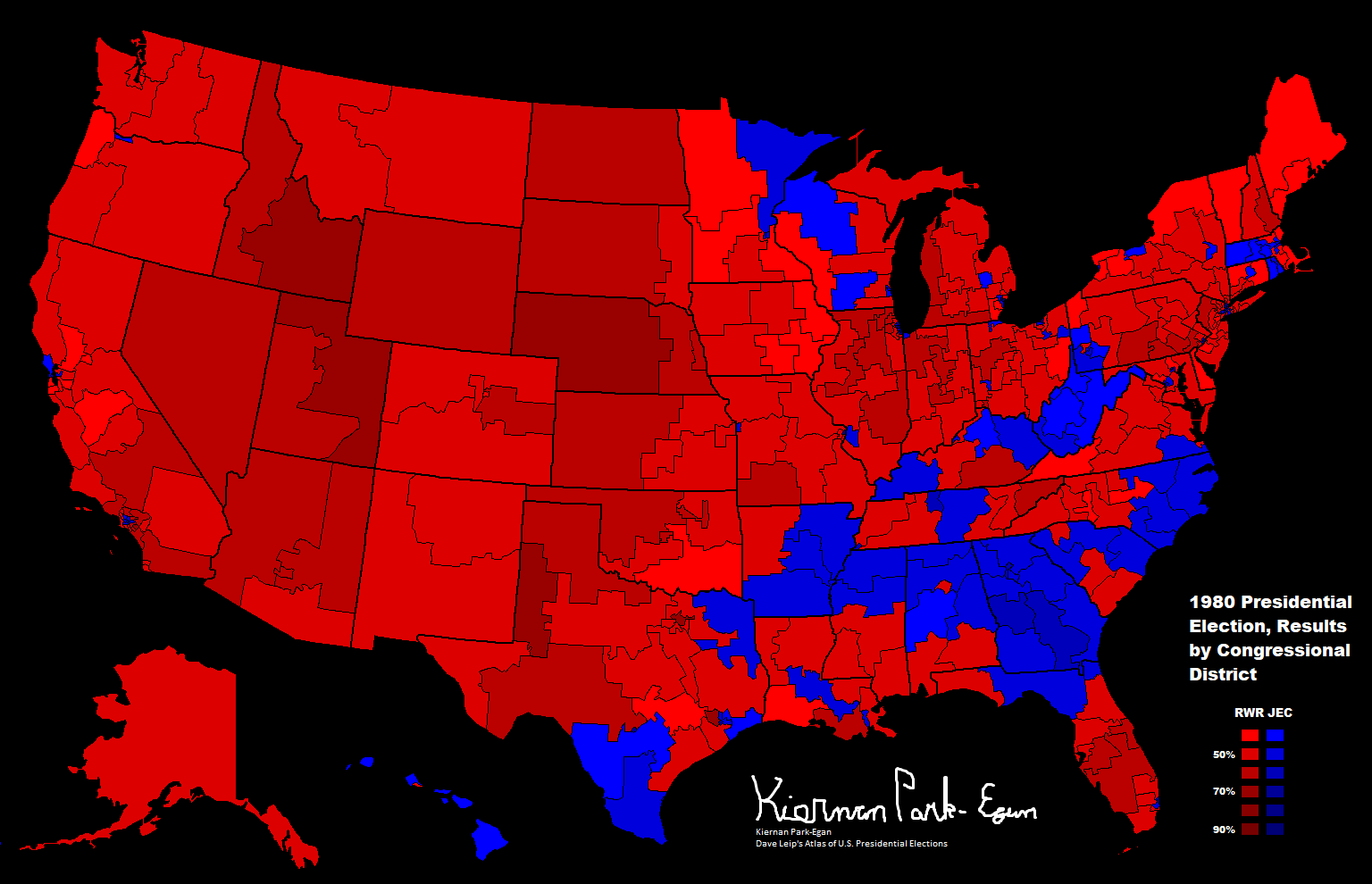
English: This map shows the results of the 1980 Presidential Election via Congressional District. |
| Date | |
| Source |
Drew and colored it on Paint. |
| Author | Fuzzybf |
- Other information
English: Unlike previous publications, this version uses blue for Carter #the Democrat) and red for Reagan (the Republican).
Licensing
I, the copyright holder of this work, hereby publish it under the following licenses:

|
Permission is granted to copy, distribute and/or modify this document under the terms of the GNU Free Documentation License, Version 1.2 or any later version published by the Free Software Foundation; with no Invariant Sections, no Front-Cover Texts, and no Back-Cover Texts. A copy of the license is included in the section entitled GNU Free Documentation License. |
This file is licensed under the
Creative Commons
Attribution-Share Alike 3.0 Unported license.
- You are free:
- to share – to copy, distribute and transmit the work
- to remix – to adapt the work
- Under the following conditions:
- attribution – You must give appropriate credit, provide a link to the license, and indicate if changes were made. You may do so in any reasonable manner, but not in any way that suggests the licensor endorses you or your use.
- share alike – If you remix, transform, or build upon the material, you must distribute your contributions under the same or compatible license as the original.
You may select the license of your choice.
File history
Click on a date/time to view the file as it appeared at that time.
| Date/Time | Thumbnail | Dimensions | User | Comment | |
|---|---|---|---|---|---|
| current | 03:12, 2 June 2018 |
| 1,536 × 990 (95 KB) | Fuzzybf | Fixed CA-26 as well as adding a title. |
| 22:22, 3 May 2018 |
 | 1,536 × 990 (89 KB) | Fuzzybf | Fixed Rhode Island, as both it's districts went to Carter, not Reagan. | |
| 01:23, 30 April 2018 |
 | 1,536 × 990 (87 KB) | Fuzzybf | Fixed Illinois. | |
| 06:59, 13 June 2015 |
 | 1,536 × 990 (89 KB) | Fuzzybf | Added signature. | |
| 00:58, 1 March 2015 |
 | 1,544 × 992 (89 KB) | Fuzzybf | Fixed Louisiana | |
| 01:05, 30 June 2013 |
 | 1,536 × 990 (83 KB) | Fuzzybf | Upgraded key. | |
| 23:53, 29 June 2013 |
 | 1,536 × 990 (81 KB) | Fuzzybf | {{subst:Upload marker added by en.wp UW}} {{Information |Description = {{en|This map shows the results of the 1980 Presidential Election via Congressional District. }} |Source = Drew and colored it on Paint.<br/> '''Previously published:''' On Dave Lei... |
File usage
No pages on the English Wikipedia use this file (pages on other projects are not listed).
Global file usage
The following other wikis use this file:
- Usage on fr.wikipedia.org
- Usage on he.wikipedia.org
- Usage on ru.wikipedia.org