
Size of this preview:
800 × 431 pixels. Other resolutions:
320 × 172 pixels |
640 × 345 pixels |
1,024 × 552 pixels |
1,280 × 689 pixels |
2,560 × 1,379 pixels |
4,610 × 2,483 pixels.
Original file (4,610 × 2,483 pixels, file size: 16.17 MB, MIME type: image/png)
| This is a file from the
Wikimedia Commons. Information from its
description page there is shown below. Commons is a freely licensed media file repository. You can help. |
|
| This is a featured picture, which means that members of the community have identified it as one of the finest images on the English Wikipedia, adding significantly to its accompanying article. If you have a different image of similar quality, be sure to upload it using the proper free license tag, add it to a relevant article, and nominate it. |
|
| This image was selected as picture of the day on the English Wikipedia for June 30, 2014. |
Summary
| Description |
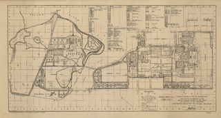
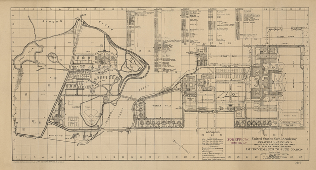
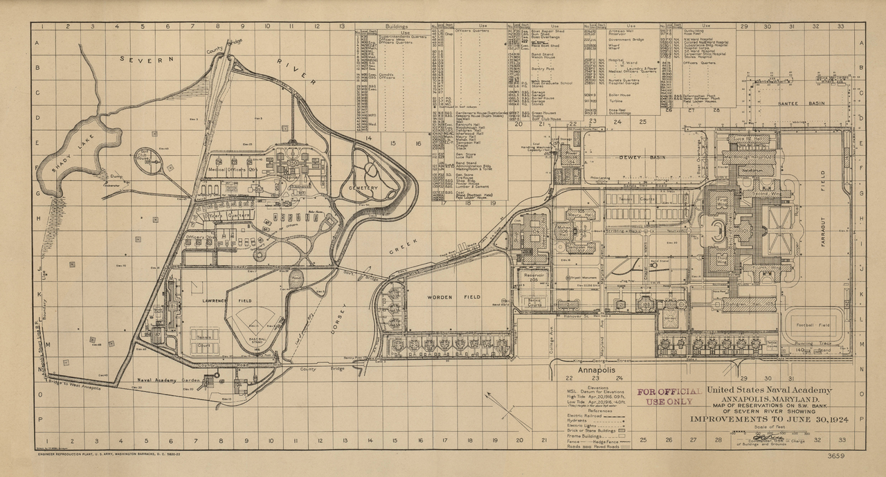
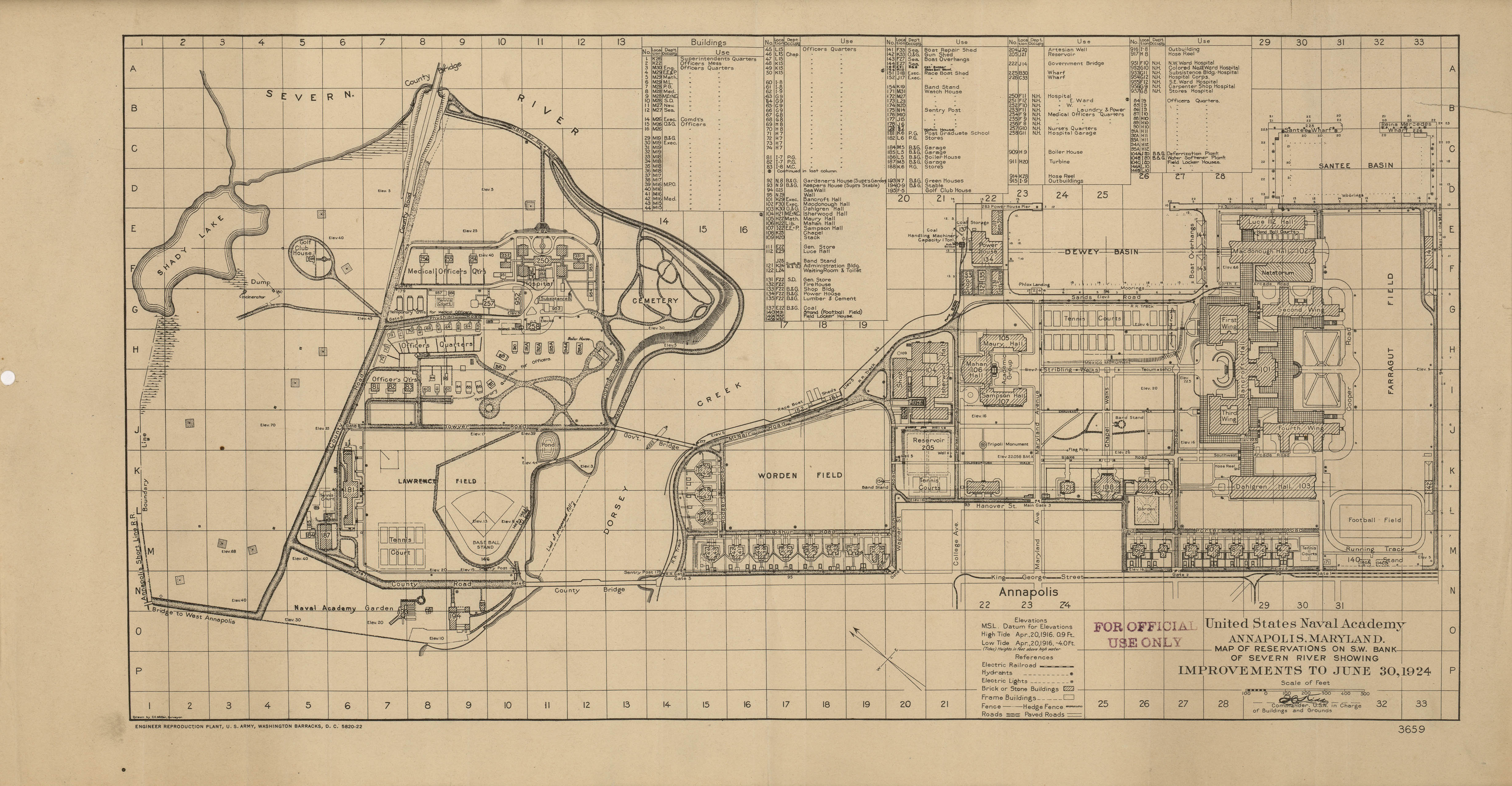
English: A 1924 map of the US Naval Academy campus. The map was drawn by C.E. Miller, surveyor, and was published by the U.S. Army.
Thompson Stadium is present on the bottom right corner of the map. The stadium was demolished in the 1980s. Several of the Academy's present athletic facilities are not present, as they did not yet exist. Citing this map: United States Army (Improvements to June 30, 1924). United States Naval Academy, Annapolis, Maryland (Map). 1 : 100. Cartography by C.E. Miller (1924 ed.). Section A1-P33. |
| Date | |
| Source | http://www.lib.utexas.edu/maps/historical/txu-pclmaps-naval_academy_1924.jpg |
| Author | C.E. Miller |
| Other versions |

Licensing
This work is in the
public domain in the United States because it is a
work prepared by an officer or employee of the United States Government as part of that person’s official duties under the terms of
Title 17, Chapter 1, Section 105 of the
US Code.
Note: This only applies to original works of the Federal Government and not to the work of any individual
U.S. state,
territory, commonwealth, county, municipality, or any other subdivision. This template also does not apply to postage stamp designs published by the
United States Postal Service
since 1978. (See §
313.6(C)(1) of Compendium of U.S. Copyright Office Practices). It also does not apply to certain US coins; see
The US Mint Terms of Use.
|
 | |
| This file has been identified as being free of known restrictions under copyright law, including all related and neighboring rights. | ||
| This is a
retouched picture, which means that it has been digitally altered from its original version. Modifications: Slightly cropped, removed scratches, smudges, and creases, slightly sharpen. Modifications made by
Awardgive.
|
|

|
This image has been assessed under the valued image criteria and is considered the most valued image on Commons within the scope: Maps of the United States Naval Academy, 1924. You can see its nomination here. |
File history
Click on a date/time to view the file as it appeared at that time.
| Date/Time | Thumbnail | Dimensions | User | Comment | |
|---|---|---|---|---|---|
| current | 21:42, 25 March 2013 |
| 4,610 × 2,483 (16.17 MB) | A Texas Historian | Remove smudges around "Lawrence Field" and "Naval Academy Gardens", and other spots |
| 23:28, 20 March 2013 |
 | 4,610 × 2,483 (12.04 MB) | A Texas Historian | Remove additional smudges and creases in scan | |
| 05:07, 17 March 2013 |
 | 4,610 × 2,483 (12.04 MB) | A Texas Historian | Remove crease and additional smudges | |
| 23:43, 14 March 2013 |
 | 4,610 × 2,483 (12.01 MB) | A Texas Historian | Minor fixes (remove smudges and small tear in scan) | |
| 02:51, 13 March 2013 |
 | 4,610 × 2,483 (12.02 MB) | A Texas Historian | User created page with UploadWizard |
File usage
The following pages on the English Wikipedia use this file (pages on other projects are not listed):
- Bancroft Hall
- United States Naval Academy Cemetery
- Talk:United States Naval Academy/Archive 2
- User:A Texas Historian/Quality
- User:Moray An Par/b
- Wikipedia:Featured picture candidates/1924 United States Naval Academy map
- Wikipedia:Featured picture candidates/March-2013
- Wikipedia:Featured pictures/Diagrams, drawings, and maps/Maps
- Wikipedia:Featured pictures thumbs/34
- Wikipedia:Picture of the day/June 2014
- Wikipedia:WikiProject Higher education
- Wikipedia:WikiProject Higher education/Accomplishments
- Wikipedia:WikiProject Military history/Featured content
- Wikipedia:WikiProject Military history/News/June 2013/Articles
- Wikipedia:WikiProject Military history/Showcase
- Wikipedia:WikiProject Military history/Showcase/FP
- Wikipedia:WikiProject United States/Featured pictures
- Wikipedia:WikiProject United States/Quality content
- Wikipedia:WikiProject United States/Recognized content
- Template:POTD/2014-06-30
- Portal:History/Recognized content
- Portal:United States/Selected picture
Global file usage
The following other wikis use this file:
- Usage on fr.wikipedia.org
- Usage on kn.wikipedia.org
- Usage on pt.wikipedia.org