
Size of this preview:
415 × 599 pixels. Other resolutions:
166 × 240 pixels |
612 × 884 pixels.
Original file (612 × 884 pixels, file size: 539 KB, MIME type: image/jpeg)
| This is a file from the
Wikimedia Commons. Information from its
description page there is shown below. Commons is a freely licensed media file repository. You can help. |
Summary
Public Domain
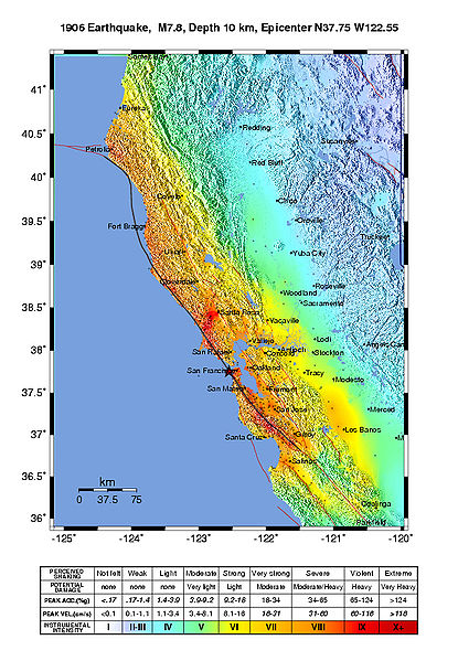
Intensity map for the 1906 San Francisco Earthquake deduced from the Lawson report
from U.S. Geological Survey Open-File Report 2005-1135
Modified Mercalli Intensity Maps for the 1906 San Francisco Earthquake Plotted in ShakeMap Format
By John Boatwright and Howard Bundock
Licensing
This image is in the
public domain in the United States because it only contains materials that originally came from the
United States Geological Survey, an agency of the
United States Department of the Interior. For more information, see
the official USGS copyright policy.
|
File history
Click on a date/time to view the file as it appeared at that time.
| Date/Time | Thumbnail | Dimensions | User | Comment | |
|---|---|---|---|---|---|
| current | 21:45, 30 May 2006 |
| 612 × 884 (539 KB) | Andre315 | Public Domain<br/> Intensity map for the 1906 San Francisco Earthquake deduced from the Lawson report<br/> from U.S. Geological Survey Open-File Report 2005-1135<br/> Modified Mercalli Intensity Maps for the 1906 San Francisco Earthquake Plotted in ShakeM |
File usage
The following pages on the English Wikipedia use this file (pages on other projects are not listed):
Global file usage
The following other wikis use this file:
- Usage on cs.wikipedia.org
- Usage on de.wikipedia.org
- Usage on fr.wikipedia.org
- Usage on gl.wikipedia.org
- Usage on hu.wikipedia.org
- Usage on ka.wikipedia.org
- Usage on ko.wikipedia.org
- Usage on ms.wikipedia.org
- Usage on nl.wikipedia.org
- Usage on tr.wikipedia.org