PhotosLocation

This is a file from the Wikimedia Commons
From Wikipedia, the free encyclopedia

Original file(3,000 × 2,955 pixels, file size: 4.19 MB, MIME type: image/jpeg)

Description
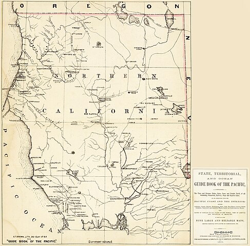
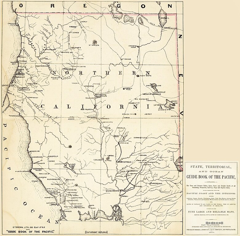
English: Historic map of Northern California in the 1860s (1866).
  • From the Sacramento Delta region, Placerville, and Tomales Bay northwards.
  • Including the former Klamath County (1851-1874) area in the northernmost state area.


Credits
  • A photomontage by Ellin Beltz of separate sheet Northern California Maps from: Holdredge, Sterling M., and Grafton Tyler Brown. State, Territorial, and Ocean Guide Book of the Pacific: Containing the Time and Distance Tables, Rates, Fares and Freight Tariff of All Steamship, Steamboat, Railway, Stage and Express Lines, on Or Connecting with the Pacific Coast and the Interior : Including California, Oregon, Nevada, Washington, Idaho, Utah, New Mexico, Arizona, British Columbia, Vancouver's and Sandwich Islands, Central and South America, Mexico : Also, Rates of Postage to All Parts of the World, Time of Arrival and Departures of Mails, Etc. Published by S.M. Holdredge, 1866. Map center is given as location below.
Date
Source http://www.davidrumsey.com as separate sheets
Author Holdredge, Sterling M., and Grafton Tyler Brown
Permission
( Reusing this file)
Public domain
Public domain
This media file is in the public domain in the United States. This applies to U.S. works where the copyright has expired, often because its first publication occurred prior to January 1, 1929, and if not then due to lack of notice or renewal. See this page for further explanation.

United States
United States
This image might not be in the public domain outside of the United States; this especially applies in the countries and areas that do not apply the rule of the shorter term for US works, such as Canada, Mainland China (not Hong Kong or Macao), Germany, Mexico, and Switzerland. The creator and year of publication are essential information and must be provided. See Wikipedia:Public domain and Wikipedia:Copyrights for more details.
This is a faithful photographic reproduction of a two-dimensional, public domain work of art. The work of art itself is in the public domain for the following reason:
Public domain

This work is in the public domain in its country of origin and other countries and areas where the copyright term is the author's life plus 100 years or fewer.


You must also include a United States public domain tag to indicate why this work is in the public domain in the United States.
The official position taken by the Wikimedia Foundation is that "faithful reproductions of two-dimensional public domain works of art are public domain".
This photographic reproduction is therefore also considered to be in the public domain in the United States. In other jurisdictions, re-use of this content may be restricted; see Reuse of PD-Art photographs for details.
Public domain I, the copyright holder of this work, release this work into the public domain. This applies worldwide.
In some countries this may not be legally possible; if so:
I grant anyone the right to use this work for any purpose, without any conditions, unless such conditions are required by law.
Object location 40° 01′ 37.56″ N, 122° 07′ 23.95″ W  Kartographer map based on OpenStreetMap.View this and other nearby images on: OpenStreetMap info

Information (Geography)

Captions

Add a one-line explanation of what this file represents

Items portrayed in this file

depicts

40°1'37.560"N, 122°7'23.948"W

image/jpeg

b3e30e8d2c54fdb32ea2799a73b7ad3c37bd5f81

4,397,547 byte

2,955 pixel

3,000 pixel

File history

Click on a date/time to view the file as it appeared at that time.

Date/TimeThumbnailDimensionsUserComment
current 16:53, 2 November 2013 Thumbnail for version as of 16:53, 2 November 20133,000 × 2,955 (4.19 MB)Ellin Beltz{{Information |Description ={{en|1=A photomontage by Ellin Beltz of separate sheet Northern California Maps from: Holdredge, Sterling M., and Grafton Tyler Brown. ''State, Territorial, and Ocean Guide Book of the Pacific: Con...
The following pages on the English Wikipedia use this file (pages on other projects are not listed):

Global file usage

The following other wikis use this file:

Metadata