This is a file from the Wikimedia Commons
From Wikipedia, the free encyclopedia

Original file(1,011 × 1,210 pixels, file size: 914 KB, MIME type: image/jpeg)

Description
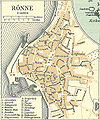
Dansk: Kort over Rønne på Bornholm
English: Map of Rønne on Bornholm in Denmark
Date circa 1900
date QS:P,+1900-00-00T00:00:00Z/9,P1480,Q5727902
Source Frems Amtskort over Danmark
Author Fotolitograferede i Generalstabens Topografiske Afdeling
Permission
( Reusing this file)
Public domain

This work is in the public domain in its country of origin and other countries and areas where the copyright term is the author's life plus 70 years or fewer.


You must also include a United States public domain tag to indicate why this work is in the public domain in the United States. Note that a few countries have copyright terms longer than 70 years: Mexico has 100 years, Jamaica has 95 years, Colombia has 80 years, and Guatemala and Samoa have 75 years. This image may not be in the public domain in these countries, which moreover do not implement the rule of the shorter term. Honduras has a general copyright term of 75 years, but it does implement the rule of the shorter term. Copyright may extend on works created by French who died for France in World War II ( more information), Russians who served in the Eastern Front of World War II (known as the Great Patriotic War in Russia) and posthumously rehabilitated victims of Soviet repressions ( more information).

Other versions used in da:Bornholm,


This is a retouched picture, which means that it has been digitally altered from its original version. Modifications: Rønne omkring 1900. The original can be viewed here: Bornholm 1900.jpg . Modifications made by Nico-dk.

Information

Captions

Town map of Rønne extracted from an island map of Bornholm with notable buildings, industry and institutions listed.

Items portrayed in this file

depicts

image/jpeg

b9385e8867458472f937c12be2ae266cc00d4dbd

936,283 byte

1,210 pixel

1,011 pixel

File history

Click on a date/time to view the file as it appeared at that time.

Date/TimeThumbnailDimensionsUserComment
current 11:22, 3 January 2009 Thumbnail for version as of 11:22, 3 January 20091,011 × 1,210 (914 KB)Cropbot{{Information |Description=da:Kort over Bornholm<br/>en:Map of Bornholm in Denmark |Source=''Frems Amtskort over Danmark'' |Date=ca. 1900 |Author= Fotolitograferede i Generalstabens Topografiske Afdeling |Permission={{PD-old}} |other_versions= used in [[
The following pages on the English Wikipedia use this file (pages on other projects are not listed):

Global file usage

The following other wikis use this file: