
Size of this PNG preview of this SVG file:
658 × 369 pixels. Other resolutions:
320 × 179 pixels |
640 × 359 pixels |
1,024 × 574 pixels |
1,280 × 718 pixels |
2,560 × 1,436 pixels.
Original file (SVG file, nominally 658 × 369 pixels, file size: 44 KB)
| This is a file from the
Wikimedia Commons. Information from its
description page there is shown below. Commons is a freely licensed media file repository. You can help. |
| Description |
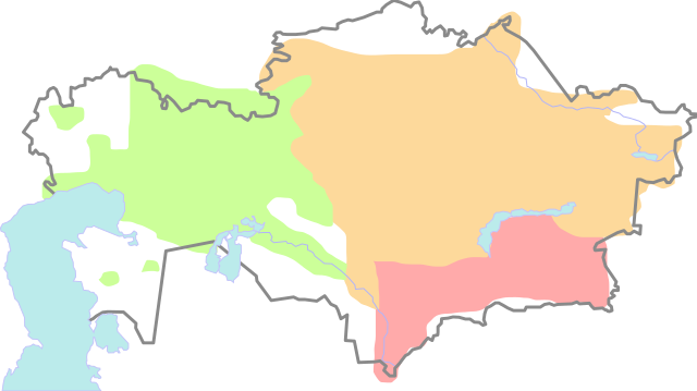
Русский: Примерные территории кочевых казахских жузов (племенных союзов) в начале XX века
Deutsch: Kasachische Orde um 1900
English: Approximate areas occupied by the three Kazakh
jüz in the early 20th century. (Key: green - Junior Jüz, yellow - Middle Jüz, red - Senior Jüz)
Français : Extension approximative des trois jüz au début du XXe siècle (vert : Petite jüz ; orange : Jüz moyenne ; rouge : Grande jüz). |
| Source | Own work |
| Author | ru:User:Wassily |
I, the copyright holder of this work, hereby publish it under the following license:

|
Permission is granted to copy, distribute and/or modify this document under the terms of the GNU Free Documentation License, Version 1.2 or any later version published by the Free Software Foundation; with no Invariant Sections, no Front-Cover Texts, and no Back-Cover Texts. A copy of the license is included in the section entitled GNU Free Documentation License. |
| This file is licensed under the Creative Commons Attribution-Share Alike 3.0 Unported license. | ||
| ||
| This licensing tag was added to this file as part of the GFDL licensing update. |
File history
Click on a date/time to view the file as it appeared at that time.
| Date/Time | Thumbnail | Dimensions | User | Comment | |
|---|---|---|---|---|---|
| current | 09:40, 29 March 2014 |
| 658 × 369 (44 KB) | Vyacheslav Nasretdinov | Reverted to version as of 10:08, 9 March 2007 |
| 09:39, 29 March 2014 |
 | 512 × 288 (20 KB) | Vyacheslav Nasretdinov | Code was updated and simplified. | |
| 10:08, 9 March 2007 |
 | 658 × 369 (44 KB) | Wassily | {{ru:}}Примерные территории кочевий казахских жузов(племенных союзов) в начале XX века. {{de:}} kasachische Orde um 1900 Category:SVG maps Category:Maps of Kazakhstan [[Category:H |
File usage
The following pages on the English Wikipedia use this file (pages on other projects are not listed):
Global file usage
The following other wikis use this file:
- Usage on ar.wikipedia.org
- Usage on azb.wikipedia.org
- Usage on az.wikipedia.org
- Usage on ba.wikipedia.org
- Usage on be.wikipedia.org
- Usage on bg.wikipedia.org
- Usage on bn.wikipedia.org
- Usage on ca.wikipedia.org
- Usage on ckb.wikipedia.org
- Usage on es.wikipedia.org
- Usage on et.wikipedia.org
- Usage on fr.wikipedia.org
- Usage on ja.wikipedia.org
- Usage on ka.wikipedia.org
- Usage on kk.wikipedia.org
- Usage on mk.wikipedia.org
- Usage on ml.wikipedia.org
- Usage on mn.wikipedia.org
- Usage on ms.wikipedia.org
- Usage on nl.wikipedia.org
- Usage on no.wikipedia.org
- Usage on pt.wikipedia.org
- Usage on ro.wikipedia.org
- Usage on ru.wikipedia.org
View more global usage of this file.