
Size of this preview:
799 × 282 pixels. Other resolutions:
320 × 113 pixels |
640 × 226 pixels |
1,024 × 362 pixels |
1,280 × 452 pixels |
2,560 × 904 pixels |
6,554 × 2,314 pixels.
Original file (6,554 × 2,314 pixels, file size: 7.35 MB, MIME type: image/jpeg)
| This is a file from the
Wikimedia Commons. Information from its
description page there is shown below. Commons is a freely licensed media file repository. You can help. |
Summary
| Description |
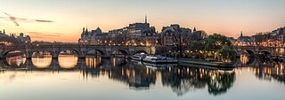
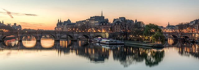
Español: La
Isla de la Cité, en París, desde el
puente de las Artes poco antes del amanecer, París, Francia.
|
| Date | |
| Source | Own work |
| Author | DXR |
| Other versions |
.jpg)
| Camera location |
| View this and other nearby images on: OpenStreetMap |
|
|---|
|
This image was selected as
picture of the day on Wikimedia Commons for
26 August 2014. It was captioned as follows: English: The Île de la Cité in Paris, France, shortly before sunrise Other languages:
Bosanski: Île de la Cité u Parizu, Francuska, neposredno pred izlazak sunca English: The Île de la Cité in Paris, France, shortly before sunrise Nederlands: Het
Île de la Cité in de Franse stad Parijs vlak voor zonsopkomst. Polski:
Île de la Cité w Paryżu tuż przed wschodem słońca Македонски: Островот
Сите во Париз на квечерина. 한국어: 일출 직전의 프랑스 파리의 시테 섬. 中文: 法国巴黎
城岛日出前的景色。 |
| This is a
retouched picture, which means that it has been digitally altered from its original version. Modifications: Blended 5-image HDR.
|
Licensing
This file is licensed under the
Creative Commons
Attribution-Share Alike 3.0 Unported license.
Attribution: Daniel Vorndran / DXR
- You are free:
- to share – to copy, distribute and transmit the work
- to remix – to adapt the work
- Under the following conditions:
- attribution – You must give appropriate credit, provide a link to the license, and indicate if changes were made. You may do so in any reasonable manner, but not in any way that suggests the licensor endorses you or your use.
- share alike – If you remix, transform, or build upon the material, you must distribute your contributions under the same or compatible license as the original.
File history
Click on a date/time to view the file as it appeared at that time.
| Date/Time | Thumbnail | Dimensions | User | Comment | |
|---|---|---|---|---|---|
| current | 12:20, 4 March 2015 |
| 6,554 × 2,314 (7.35 MB) | Paris 16 | |
| 10:39, 20 March 2014 |
 | 6,554 × 3,009 (5.68 MB) | DXR | VicuñaUploader 1.20 |
File usage
The following pages on the English Wikipedia use this file (pages on other projects are not listed):
Global file usage
The following other wikis use this file:
- Usage on ar.wikipedia.org
- Usage on be-tarask.wikipedia.org
- Usage on bn.wikipedia.org
- Usage on bxr.wikipedia.org
- Usage on crh.wikipedia.org
- Usage on cv.wikipedia.org
- Usage on de.wikipedia.org
- Usage on de.wikivoyage.org
- Usage on fr.wikipedia.org
- Usage on he.wikipedia.org
- Usage on hu.wikipedia.org
- Usage on ja.wikipedia.org
- Usage on ka.wikipedia.org
- Usage on kk.wikipedia.org
- Usage on ko.wikipedia.org
- Usage on krc.wikipedia.org
- Usage on lbe.wikipedia.org
- Usage on mg.wikipedia.org
- Usage on os.wikipedia.org
- Usage on pt.wikipedia.org
- Usage on ro.wikipedia.org
- Usage on ru.wikipedia.org
- Usage on ru.wikinews.org
- Usage on sah.wikipedia.org
- Usage on sl.wikipedia.org
- Usage on tt.wikipedia.org
- Usage on uk.wikipedia.org
- Usage on ur.wikipedia.org
- Usage on vi.wikipedia.org
- Usage on xal.wikipedia.org
- Usage on zh.wikipedia.org