
Size of this preview:
800 × 600 pixels. Other resolutions:
320 × 240 pixels |
640 × 480 pixels |
1,024 × 768 pixels |
1,280 × 960 pixels.
Original file (1,280 × 960 pixels, file size: 129 KB, MIME type: image/jpeg)
| This is a file from the
Wikimedia Commons. Information from its
description page there is shown below. Commons is a freely licensed media file repository. You can help. |
Summary
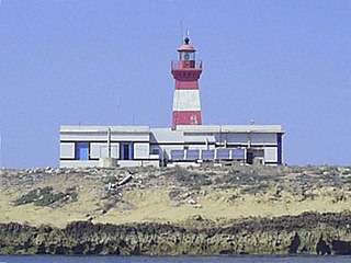
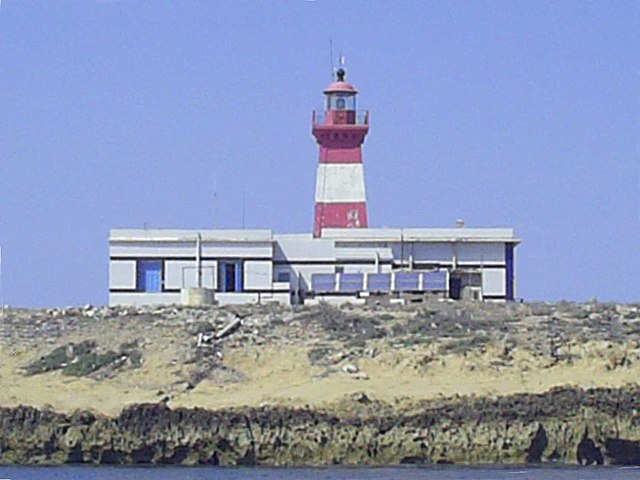
| Description | Zoom on building of 'Ile Plane' Ghar El Melh, Tunisia. The ile is 8 meters of height from sea level and contains a lighthouse (+12 meters height). Localised at the east of Ras Sidi Ali El Mekki and 2,3 miles from the coast (37º 10,8' N - 10º 19,7' E). |
| Date | |
| Source | https://www.flickr.com/photos/abdelmoumen/1025186865/ |
| Author | Ahmed ABDELMOUMEN |
| Permission ( Reusing this file) |
Autorized by the author by email to me on 7 August 2007: "pour les photos bien sur tu peux les utiliser". |
Licensing
This file is licensed under the
Creative Commons
Attribution-Share Alike 2.0 Generic license.
- You are free:
- to share – to copy, distribute and transmit the work
- to remix – to adapt the work
- Under the following conditions:
- attribution – You must give appropriate credit, provide a link to the license, and indicate if changes were made. You may do so in any reasonable manner, but not in any way that suggests the licensor endorses you or your use.
- share alike – If you remix, transform, or build upon the material, you must distribute your contributions under the same or compatible license as the original.
| This image, originally posted to Flickr, was reviewed on 17 October 2007 by the administrator or reviewer Davepape, who confirmed that it was available on Flickr under the stated license on that date. |
File history
Click on a date/time to view the file as it appeared at that time.
| Date/Time | Thumbnail | Dimensions | User | Comment | |
|---|---|---|---|---|---|
| current | 19:53, 23 October 2007 |
| 1,280 × 960 (129 KB) | Iunity | redressement |
| 16:58, 16 August 2007 |
 | 1,280 × 960 (116 KB) | Citizen59 | {{Information |Description=Zoom on building of 'Ile Plane' Ghar El Melh, Tunisia |Source=http://www.flickr.com/photos/abdelmoumen/1025186865/ |Date=5 August 2007 |Author=Ahmed ABDELMOUMEN |Permission=Autorized by the author by email to me on 7 August 2007 |
File usage
The following pages on the English Wikipedia use this file (pages on other projects are not listed):
Global file usage
The following other wikis use this file:
- Usage on ar.wikipedia.org
- Usage on ca.wikipedia.org
- Usage on de.wikipedia.org
- Usage on es.wikipedia.org
- Usage on fr.wikipedia.org
- Usage on ru.wikipedia.org
- Usage on uk.wikipedia.org
- Usage on www.wikidata.org