No higher resolution available.
Western-settlement-eng.png (638 × 443 pixels, file size: 158 KB, MIME type: image/png)
| This is a file from the
Wikimedia Commons. Information from its
description page there is shown below. Commons is a freely licensed media file repository. You can help. |
Summary
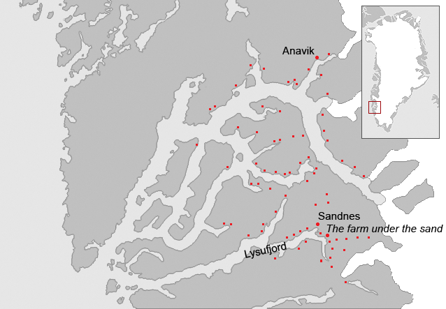
| Description | Map of the Western settlement of the Norse in medieval Greenland. The area is approximately the modern Municipality of Nuuk. The known farms and churches are identified on the map as some probable geographical names. The red dots indicate known farm ruins. |
| Date | |
| Source |
Saga trails, Jette Arneborg, Danmarks Nationalmuseum, ISBN: 87-988378-3-4 Grønlands forhistorie,red. Hans Christian Gulløv, Gyldendal 2005, ISBN:87-02-01724-5 Á hjara veraldar, Guðmundur J. Guðmundsson, Sögufélagið, 2005, ISBN: 9979-9636-8-9 |
| Author | Masae |
| Permission ( Reusing this file) |
Own work |
Licensing
I, the copyright holder of this work, hereby publish it under the following licenses:

|
Permission is granted to copy, distribute and/or modify this document under the terms of the GNU Free Documentation License, Version 1.2 or any later version published by the Free Software Foundation; with no Invariant Sections, no Front-Cover Texts, and no Back-Cover Texts. A copy of the license is included in the section entitled GNU Free Documentation License. |
| This file is licensed under the Creative Commons Attribution-Share Alike 3.0 Unported license. | ||
| ||
| This licensing tag was added to this file as part of the GFDL licensing update. |
This file is licensed under the
Creative Commons Attribution-Share Alike
2.5 Generic,
2.0 Generic and
1.0 Generic license.
- You are free:
- to share – to copy, distribute and transmit the work
- to remix – to adapt the work
- Under the following conditions:
- attribution – You must give appropriate credit, provide a link to the license, and indicate if changes were made. You may do so in any reasonable manner, but not in any way that suggests the licensor endorses you or your use.
- share alike – If you remix, transform, or build upon the material, you must distribute your contributions under the same or compatible license as the original.
You may select the license of your choice.
File history
Click on a date/time to view the file as it appeared at that time.
| Date/Time | Thumbnail | Dimensions | User | Comment | |
|---|---|---|---|---|---|
| current | 19:12, 3 January 2007 |
| 638 × 443 (158 KB) | Masae~commonswiki | {{Information |Description=Map of the Western settlement of the Norse in medieval Greenland. The area is approximately the modern Municipality of Nuuk. The known farms and churches are identified on the map as some probable geographical names. The red do |
| 08:58, 8 December 2006 |
 | 638 × 443 (158 KB) | Masae~commonswiki | {{Information |Description=Map of the Western settlement of the Norse in medieval Greenland. The area is approximately the modern Municipality of Nuuk. The known farms and churches are identified on the map as some probable geographical names. The red do | |
| 16:25, 7 December 2006 |
 | 638 × 443 (100 KB) | Masae~commonswiki | {{Information |Description=Map of the Western settlement of the Norse in medieval Greenland. The area is approximately the modern Municipality of Nuuk. The known farms and churches are identified on the map as some probable geographical names. The red do | |
| 15:50, 7 December 2006 |
 | 638 × 443 (90 KB) | Masae~commonswiki | {{Information |Description=Map of the Western settlement of the Norse in medieval Greenland. The area is approximately the modern Municipality of Nuuk. The known farms and churches are identified on the map as some probable geographical names. The red do |
File usage
The following pages on the English Wikipedia use this file (pages on other projects are not listed):
Global file usage
The following other wikis use this file:
- Usage on arz.wikipedia.org
- Usage on ca.wikipedia.org
- Usage on da.wikipedia.org
- Usage on de.wikipedia.org
- Usage on es.wikipedia.org
- Usage on fr.wikipedia.org
- Usage on he.wikipedia.org
- Usage on hu.wikipedia.org
- Usage on it.wikipedia.org
- Usage on ko.wikipedia.org
- Usage on nl.wikipedia.org
- Usage on nn.wikipedia.org
- Usage on no.wikipedia.org
- Usage on pl.wikipedia.org
- Usage on pt.wikipedia.org
- Usage on ru.wikipedia.org
- Usage on sv.wikipedia.org
- Usage on www.wikidata.org
- Usage on zh.wikipedia.org