
Size of this preview:
469 × 599 pixels. Other resolutions:
188 × 240 pixels |
376 × 480 pixels |
601 × 768 pixels |
801 × 1,024 pixels |
1,603 × 2,048 pixels |
7,201 × 9,201 pixels.
Original file (7,201 × 9,201 pixels, file size: 8.9 MB, MIME type: image/jpeg)
| This is a file from the
Wikimedia Commons. Information from its
description page there is shown below. Commons is a freely licensed media file repository. You can help. |
| Warning | The original file is very high-resolution. It might not load properly or could cause your browser to freeze when opened at full size. |
|---|
Summary
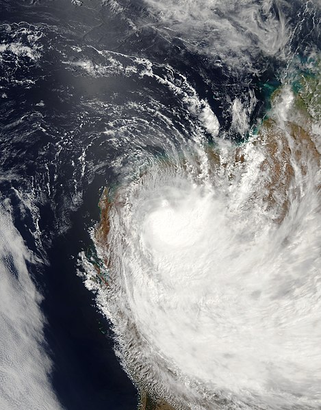
| Description | Tropical Cyclone Emma formed as a low-intensity storm system and built to cyclone strength only briefly. But Emma’s brief cyclone status belied its size and rainfall. The Moderate Resolution Imaging Spectrometer (MODIS) instrument on the Aqua observed the storm system as it was losing strength, and hence its tropical cyclone status, on February 28, 2006, at 5:55 UTC (1:55 p.m. local time). At this time, the cyclone had peak winds of roughly 55 kilometers per hour (35 miles per hour). As the image shows, the storm system covered an enormous area, extending over almost the entire extent of Western Australia. With it came heavy rain and substantial flooding to the Pilbara Region, the northwestern corner of Western Australia, where the storm system came ashore. | |||||
| Date | ||||||
| Source | http://earthobservatory.nasa.gov/NaturalHazards/natural_hazards_v2.php3?img_id=13385 | |||||
| Author | NASA image created by Jesse Allen, Earth Observatory, using data obtained from the Goddard Earth Sciences DAAC. | |||||
| Permission ( Reusing this file) |
|

File history
Click on a date/time to view the file as it appeared at that time.
| Date/Time | Thumbnail | Dimensions | User | Comment | |
|---|---|---|---|---|---|
| current | 17:12, 11 January 2019 |
| 7,201 × 9,201 (8.9 MB) | FleurDeOdile | remove missing data |
| 14:40, 29 August 2006 |
 | 6,476 × 8,635 (5.21 MB) | Good kitty | == Summary == {{Information |Description=Tropical Cyclone Emma formed as a low-intensity storm system and built to cyclone strength only briefly. But Emma’s brief cyclone status belied its size and rainfall. The Moderate Resolution Imaging Spectrometer |
File usage
The following pages on the English Wikipedia use this file (pages on other projects are not listed):
Global file usage
The following other wikis use this file:
- Usage on pt.wikipedia.org
- Usage on zh.wikipedia.org