
Size of this preview:
460 × 600 pixels. Other resolutions:
184 × 240 pixels |
368 × 480 pixels |
589 × 768 pixels |
785 × 1,024 pixels |
1,570 × 2,048 pixels |
4,600 × 6,000 pixels.
Original file (4,600 × 6,000 pixels, file size: 3.58 MB, MIME type: image/jpeg)
| This is a file from the
Wikimedia Commons. Information from its
description page there is shown below. Commons is a freely licensed media file repository. You can help. |
Summary
| Description |
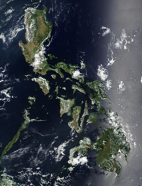
Satellite image of Philippines in March 2002. |
| Date | |
| Source | http://visibleearth.nasa.gov/view_rec.php?id=2689 |
| Author | NASA |
Licensing
| This file is in the public domain in the United States because it was solely created by NASA. NASA copyright policy states that "NASA material is not protected by copyright unless noted". (See Template:PD-USGov, NASA copyright policy page or JPL Image Use Policy.) | ||
 |
Warnings:
|
File history
Click on a date/time to view the file as it appeared at that time.
| Date/Time | Thumbnail | Dimensions | User | Comment | |
|---|---|---|---|---|---|
| current | 11:32, 21 December 2004 |
| 4,600 × 6,000 (3.58 MB) | Hautala | {{PD-USGov-NASA}} Satellite image of Philippines in March 2002. Taken from NASA's Visible Earth http://visibleearth.nasa.gov/cgi-bin/viewrecord?12847 . Description: Red dots (or outlines in the high-resolution imagery) indicate MODIS9 detection of thermal |
File usage
The following pages on the English Wikipedia use this file (pages on other projects are not listed):
- Deforestation by continent
- Deforestation in the Philippines
- Outline of the Philippines
- Wikipedia:Featured picture candidates/February-2014
- Wikipedia:Featured picture candidates/Philippines (Satellite)
- Wikipedia:Featured picture candidates/Satellite image of the Philippines
- Wikipedia:Featured picture candidates/September-2012
Global file usage
The following other wikis use this file:
- Usage on af.wikipedia.org
- Usage on bg.wikipedia.org
- Usage on bn.wikipedia.org
- Usage on da.wikipedia.org
- Usage on de.wikipedia.org
- Usage on de.wikinews.org
- Usage on en.wikiversity.org
- Usage on en.wiktionary.org
- Usage on fi.wikipedia.org
- Usage on he.wikipedia.org
- תבנית:הידעת? 5 בנובמבר - סדרה 2
- פורטל:ארצות הברית/הידעת?/קטעי הידעת
- פורטל:ארצות הברית/הידעת?/50
- פורטל:יפן/הידעת?/קטעי הידעת
- תבנית:הידעת? 5 בנובמבר 2014
- ויקיפדיה:הידעת?/2014/נובמבר
- ויקיפדיה:הידעת?/2016/נובמבר
- תבנית:הידעת? 5 בנובמבר 2016
- ויקיפדיה:הידעת?/2018/נובמבר
- תבנית:הידעת? 18 בנובמבר 2018
- תבנית:הידעת? 1 בנובמבר 2019
- ויקיפדיה:הידעת?/2019/נובמבר
- ויקיפדיה:הידעת?/2021/נובמבר
- תבנית:הידעת? 7 בנובמבר 2021
- פורטל:יפן/הידעת?/23
- תבנית:הידעת? 5 בנובמבר 2023
- ויקיפדיה:הידעת?/2023/נובמבר
- Usage on ht.wikipedia.org
- Usage on incubator.wikimedia.org
- Usage on mdf.wikipedia.org
- Usage on nl.wikipedia.org
- Usage on nl.wiktionary.org
- Usage on no.wikipedia.org
- Usage on pap.wikipedia.org
- Usage on pl.wikinews.org
- Usage on qu.wikipedia.org
- Usage on sk.wikipedia.org
- Usage on sm.wikipedia.org
- Usage on sr.wikinews.org
- Usage on trv.wikipedia.org
- Usage on www.wikidata.org
- Usage on zh.wikipedia.org
- Usage on zh.wiktionary.org