
Size of this preview:
800 × 190 pixels. Other resolutions:
320 × 76 pixels |
640 × 152 pixels |
1,024 × 243 pixels |
1,280 × 303 pixels |
7,956 × 1,886 pixels.
Original file (7,956 × 1,886 pixels, file size: 4.75 MB, MIME type: image/jpeg)
| This is a file from the
Wikimedia Commons. Information from its
description page there is shown below. Commons is a freely licensed media file repository. You can help. |
.jpg)
Summary
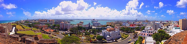
| Description | Panoramic of Old San Juan, San Juan Bay, and Santurce in Puerto Rico from atop Castillo San Cristobal |
| Date | |
| Source | San Juan Puerto Rico |
| Author | Chad Sparkes from Kissimmee,Florida, United States |
| Camera location |
| View this and other nearby images on: OpenStreetMap |
|
|---|
.jpg¶ms=018.466105_N_-066.126450_E_globe:Earth_type:camera_source:Flickr_&language=en)
Licensing
This file is licensed under the
Creative Commons
Attribution 2.0 Generic license.
- You are free:
- to share – to copy, distribute and transmit the work
- to remix – to adapt the work
- Under the following conditions:
- attribution – You must give appropriate credit, provide a link to the license, and indicate if changes were made. You may do so in any reasonable manner, but not in any way that suggests the licensor endorses you or your use.
| This image was originally posted to Flickr by Thanks for over 2 million views!! at https://flickr.com/photos/113086034@N04/33519972611 ( archive). It was reviewed on 19 February 2018 by FlickreviewR 2 and was confirmed to be licensed under the terms of the cc-by-2.0. |
File history
Click on a date/time to view the file as it appeared at that time.
| Date/Time | Thumbnail | Dimensions | User | Comment | |
|---|---|---|---|---|---|
| current | 10:34, 19 February 2018 |
| 7,956 × 1,886 (4.75 MB) | Junior Jumper | Transferred from Flickr via Flickr2Commons |
File usage
The following pages on the English Wikipedia use this file (pages on other projects are not listed):
Global file usage
The following other wikis use this file:
- Usage on es.wikipedia.org
- Usage on mt.wikipedia.org
.jpg)