
Size of this preview:
490 × 599 pixels. Other resolutions:
196 × 240 pixels |
392 × 480 pixels |
628 × 768 pixels |
1,134 × 1,387 pixels.
Original file (1,134 × 1,387 pixels, file size: 1.53 MB, MIME type: image/png)
| This is a file from the
Wikimedia Commons. Information from its
description page there is shown below. Commons is a freely licensed media file repository. You can help. |
| Description |
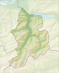
Deutsch: Reliefkarte des Kantons Glarus
Topographischer Hintergrund:
NASA Shuttle Radar Topography Mission (public domain). SRTM3 v.2. |
||||||||
| Date | |||||||||
| Source | Own work | ||||||||
| Author | Tschubby | ||||||||
| Permission ( Reusing this file) |
I, the copyright holder of this work, hereby publish it under the following licenses:
This file is licensed under the
Creative Commons Attribution-Share Alike
2.5 Generic,
2.0 Generic and
1.0 Generic license.
You may select the license of your choice. |
||||||||
| Other versions |
 |

File history
Click on a date/time to view the file as it appeared at that time.
| Date/Time | Thumbnail | Dimensions | User | Comment | |
|---|---|---|---|---|---|
| current | 19:22, 5 December 2013 |
| 1,134 × 1,387 (1.53 MB) | Tschubby | {{Information |Description= |Source= |Date= |Author= |Permission= |other_versions= }} |
| 19:00, 5 December 2013 |
 | 1,134 × 1,387 (1.53 MB) | Tschubby | {{Information |Description= {{de| Reliefkarte des Kantons Glarus}} Topographischer Hintergrund: [http://www2.jpl.nasa.gov/srtm NASA Shuttle Radar Topography Mission] (public domain). SRTM3 v.2. |Source={{own}} |Date= 2013-12-05 |Author= [[:de:User:Tsch... |
File usage
The following pages on the English Wikipedia use this file (pages on other projects are not listed):
- Berglimattsee
- Bilten
- Chüebodensee
- Ennenda
- Filzbach
- Garichtisee
- Glarus
- Glarus Nord
- Glarus Süd
- Klöntalersee
- Limmernsee
- List of castles and fortresses in Switzerland
- Mollis
- Muttsee
- Mühlehorn
- Netstal
- Niederurnen
- Näfels
- Oberblegisee
- Obersee (Glarus)
- Oberurnen
- Obstalden
- Riedern
- Spaneggsee
- Talalpsee
- Vorburg
- Waldisee
- Walensee
- Weesen railway station
- Template:List of castles and fortresses in Canton Glarus/location map
- Module:Location map/data/Canton of Glarus
- Module:Location map/data/Canton of Glarus/doc
Global file usage
The following other wikis use this file:
- Usage on de.wikipedia.org
- Linth
- Kerenzerberg
- Limmerensee
- Muttseehöhle
- Windloch (Klöntal)
- Bifertenstock
- Ortstock
- Eggstöcke
- Muttsee
- Liste von Burgen und Schlössern in der Schweiz
- Kerenzertunnel
- Claridenhütte
- Rauti
- Wiggis
- Rautispitz
- Rossalpelispitz
- Planurahütte
- Planggenstock
- Fridolinshütte
- Muttseehütte
- Gassenstock
- Kraftwerke Linth-Limmern
- Gemsfairenstock
- Wikipedia:Kartenwerkstatt/Positionskarten/Europa
- Oberblegisee
- Ruchi
- Grünhornhütte
- Chüebodensee
- Leglerhütte
- Piz Segnas
- Tschingelhörner
- Ofen (Berg)
- Vorderglärnisch
- Nidfurner Turm
- Mürtschenstock
- Benutzer:DF5GO/Spielwiese
- Foostock
- Foopass
- Richetlipass
- Rüchi
- Nüschenstock
- Vorlage:Positionskarte Schweiz Glarus
- Aussichtsturm Schwanden
- Zeinenfurggel
- Flugplatz Mollis
- Benutzer:Opoisson/Spielwiese/Kistenpasshütte
- Martinsmadhütte
- Hochmättli
- Silberspitz
- Wikipedia:Fragen zur Wikipedia/Archiv/2016/Woche 24
View more global usage of this file.