
Size of this preview:
800 × 451 pixels. Other resolutions:
320 × 180 pixels |
640 × 361 pixels |
1,118 × 630 pixels.
Original file (1,118 × 630 pixels, file size: 589 KB, MIME type: image/jpeg)
| This is a file from the
Wikimedia Commons. Information from its
description page there is shown below. Commons is a freely licensed media file repository. You can help. |
| Description |
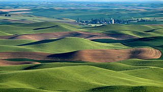
We were hearing a sound like a plane and couldn't figure out where the plane was. Finally one of us spotted a yellow plane flying in the area of the grain elevator! Amazing. Steptoe Butte is the perfect high point in the Palouse Hills to catch the shadow and light play on the hills of the area at sunset and sunrise. This is a morning capture. During one of the ice ages (about 15,000 years ago) Clark Fork River (Montana) was dammed by ice, forming Missoula Lake, the top of which was about 2,000 feet in elevation. About every 2 to 60 years there was thermal erosion of the ice dam and it would collapse and let a flood go through for about 3 days -- whatever time it took to drain Missoula Lake. Many layers of silt left by multiple Missoula floods were topped by loess (dirt blown on top) which made for great rolling hills of farmlands. |
| Date | |
| Source | Hills, grain elevator, and little yellow plane (really) |
| Author | Lynn Suckow from Walla Walla, WA, USA |
Licensing
This file is licensed under the
Creative Commons
Attribution-Share Alike 2.0 Generic license.
- You are free:
- to share – to copy, distribute and transmit the work
- to remix – to adapt the work
- Under the following conditions:
- attribution – You must give appropriate credit, provide a link to the license, and indicate if changes were made. You may do so in any reasonable manner, but not in any way that suggests the licensor endorses you or your use.
- share alike – If you remix, transform, or build upon the material, you must distribute your contributions under the same or compatible license as the original.
| This image, originally posted to Flickr, was reviewed on January 13, 2009 by the administrator or reviewer File Upload Bot (Magnus Manske), who confirmed that it was available on Flickr under the stated license on that date. |
File history
Click on a date/time to view the file as it appeared at that time.
| Date/Time | Thumbnail | Dimensions | User | Comment | |
|---|---|---|---|---|---|
| current | 15:03, 13 January 2009 |
| 1,118 × 630 (589 KB) | File Upload Bot (Magnus Manske) | {{Information |Description= We were hearing a sound like a plane and couldn't figure out where the plane was. Finally one of us spotted a yellow plane flying in the area of the grain elevator! Amazing. Steptoe Butte is the perfect high point in the Pa |
File usage
The following pages on the English Wikipedia use this file (pages on other projects are not listed):
Global file usage
The following other wikis use this file:
- Usage on ar.wikipedia.org
- Usage on de.wikipedia.org
- Usage on en.wikivoyage.org
- Usage on es.wikipedia.org
- Usage on ga.wikipedia.org
- Usage on hsb.wikipedia.org
- Usage on it.wikipedia.org
- Usage on it.wikibooks.org
- Usage on it.wikiversity.org
- Usage on ja.wikipedia.org
- Usage on nl.wikipedia.org
- Usage on ru.wikipedia.org
- Usage on simple.wikipedia.org
- Usage on tr.wikipedia.org
- Usage on uk.wikipedia.org
- Usage on vi.wikipedia.org