
Size of this PNG preview of this SVG file:
609 × 600 pixels. Other resolutions:
244 × 240 pixels |
488 × 480 pixels |
780 × 768 pixels |
1,040 × 1,024 pixels |
2,080 × 2,048 pixels |
1,286 × 1,266 pixels.
Original file (SVG file, nominally 1,286 × 1,266 pixels, file size: 395 KB)
| This is a file from the
Wikimedia Commons. Information from its
description page there is shown below. Commons is a freely licensed media file repository. You can help. |
| Description |
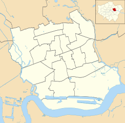
Blank map of the London Borough of Newham, showing electoral wards. Equirectangular map projection on WGS 84 datum, with N/S stretched 160% Geographic limits:
|
| Date | |
| Source |
|
| Author | Nilfanion |
| Permission ( Reusing this file) |
This file is licensed under the
Creative Commons
Attribution-Share Alike 3.0 Unported license. Attribution: Contains Ordnance Survey data © Crown copyright and database right
|
File history
Click on a date/time to view the file as it appeared at that time.
| Date/Time | Thumbnail | Dimensions | User | Comment | |
|---|---|---|---|---|---|
| current | 22:13, 28 July 2011 |
| 1,286 × 1,266 (395 KB) | Nilfanion | {{Information |Description=Blank map of the London Borough of Newham, showing electoral wards. Equirectangular map projection on WGS 84 datum, with N/S stretched 160% Geographic limits: *West: 0.03W *East: 0.1E *North: 51. |
File usage
The following pages on the English Wikipedia use this file (pages on other projects are not listed):
Global file usage
The following other wikis use this file:
- Usage on fr.wikipedia.org
- Usage on he.wikipedia.org
- Usage on pl.wikipedia.org
- Boleyn Ground
- Port lotniczy Londyn-City
- Canning Town (stacja metra)
- West Ham (stacja kolejowa)
- Stratford (stacja)
- Stadion Olimpijski w Londynie
- London Velopark
- Basketball Arena w Londynie
- Aquatics Centre w Londynie
- Water Polo Arena
- ArcelorMittal Orbit
- ExCeL
- Moduł:Mapa/dane/Newham
- Moduł:Mapa/dane/GB-NWM
- Silvertown
- Usage on pl.wikibooks.org