Size of this preview:
600 × 600 pixels. Other resolutions:
240 × 240 pixels |
480 × 480 pixels |
768 × 768 pixels |
1,024 × 1,024 pixels.
Original file (1,024 × 1,024 pixels, file size: 294 KB, MIME type: image/jpeg)
| This is a file from the
Wikimedia Commons. Information from its
description page there is shown below. Commons is a freely licensed media file repository. You can help. |
| Description |
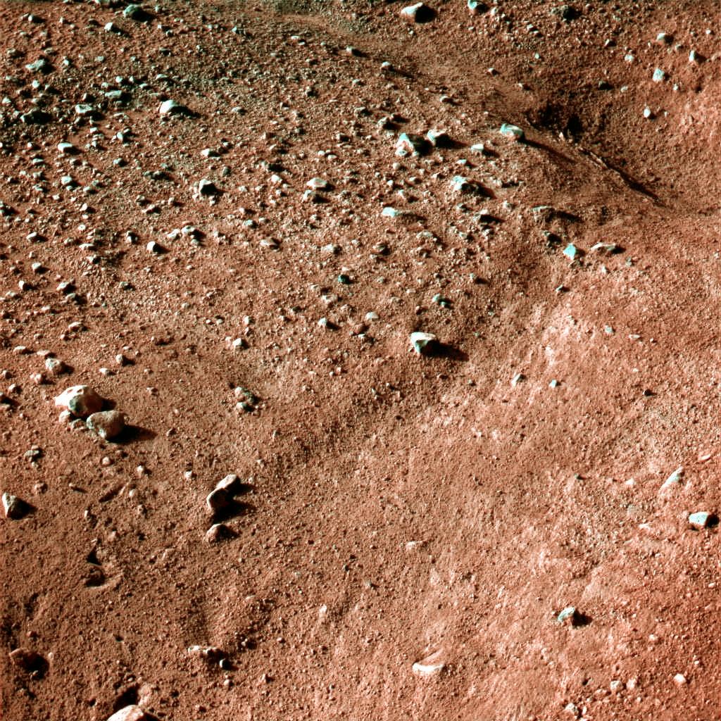
This image shows a polygonal pattern in the ground near NASA's Phoenix Mars Lander, similar in appearance to icy ground in the arctic regions of Earth. Phoenix was confirmed to have touched down on the Red Planet at 22:53 GMT, 25 May, 2008, in an arctic region called Vastitas Borealis, at 68 degrees north latitude, 234 degrees east longitude. This is an approximate-colour image taken shortly after landing by the spacecraft's Surface Stereo Imager, inferred from two colour filters, a violet, 450-nanometre filter and an infrared, 750-nanometre filter. The Phoenix Mission is led by the University of Arizona, Tucson, on behalf of NASA. Project management of the mission is by NASA's Jet Propulsion Laboratory, Pasadena, California. Spacecraft development is by Lockheed Martin Space Systems, Denver. |
|||||
| Date | ||||||
| Source | http://www.nasa.gov/mission_pages/phoenix/images/press/false_color_postcard_edr.html | |||||
| Author | NASA/JPL-Caltech/University of Arizona | |||||
| Permission ( Reusing this file) |
|

File history
Click on a date/time to view the file as it appeared at that time.
| Date/Time | Thumbnail | Dimensions | User | Comment | |
|---|---|---|---|---|---|
| current | 07:51, 26 May 2008 |
| 1,024 × 1,024 (294 KB) | WDGraham | {{Information |Description=This image shows a polygonal pattern in the ground near NASA's Phoenix Mars Lander, similar in appearance to icy ground in the arctic regions of Earth. Phoenix was confirmed to have touched down on the Red Planet at 22:53 GMT, |
File usage
The following pages on the English Wikipedia use this file (pages on other projects are not listed):
Global file usage
The following other wikis use this file:
- Usage on be.wikipedia.org
- Usage on bg.wikipedia.org
- Usage on ca.wikipedia.org
- Usage on da.wikipedia.org
- Usage on de.wikipedia.org
- Usage on de.wikinews.org
- Usage on en.wikinews.org
- Usage on eo.wikipedia.org
- Usage on fa.wikipedia.org
- Usage on hu.wikipedia.org
- Usage on hu.wikinews.org
- Usage on hy.wikipedia.org
- Usage on incubator.wikimedia.org
- Usage on it.wikinews.org
- Usage on ja.wikipedia.org
- Usage on kk.wikipedia.org
- Usage on mk.wikipedia.org
- Usage on nds.wikipedia.org
- Usage on nl.wikipedia.org
- Usage on pt.wikipedia.org
- Usage on ru.wikipedia.org
- Usage on ru.wikinews.org
- Usage on sv.wikipedia.org
- Usage on tr.wikipedia.org
- Usage on uk.wikipedia.org
- Usage on zh.wikipedia.org