
Size of this PNG preview of this SVG file:
340 × 330 pixels. Other resolutions:
247 × 240 pixels |
495 × 480 pixels |
791 × 768 pixels |
1,055 × 1,024 pixels |
2,110 × 2,048 pixels.
Original file (SVG file, nominally 340 × 330 pixels, file size: 84 KB)
| This is a file from the
Wikimedia Commons. Information from its
description page there is shown below. Commons is a freely licensed media file repository. You can help. |
Summary
This W3C-unspecified
vector image was created with
Inkscape .
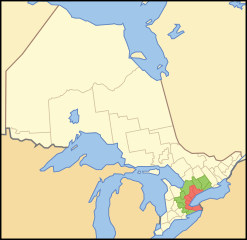
| Description | A map showing which census divisions make up the en:Golden Horseshoe (red) and the Greater Golden Horseshoe (Green) |
| Date | |
| Source | Crop and trace of Image:Canada (geolocalisation).svg; trace of Image:Ontario subdivisions.PNG. |
| Author | Vidioman |
| Other versions | en:Image:Goldhorse.PNG |
.svg)
Licensing
| I, the copyright holder of this work, release this work into the
public domain. This applies worldwide. In some countries this may not be legally possible; if so: I grant anyone the right to use this work for any purpose, without any conditions, unless such conditions are required by law. |
File history
Click on a date/time to view the file as it appeared at that time.
| Date/Time | Thumbnail | Dimensions | User | Comment | |
|---|---|---|---|---|---|
| current | 12:08, 15 October 2007 |
| 340 × 330 (84 KB) | Vidioman | {{Created with Inkscape}} {{Information |Description=A map showing which census divisions make up the Golden Horseshoe (red) and the Greater Golden Horseshoe (Green) |Source=Crop and trace of Image:Canada (geolocalisation).svg; trace of [http://en.wi |
.svg)
File usage
The following pages on the English Wikipedia use this file (pages on other projects are not listed):
- Aldershot, Burlington
- Bayfront Park (Hamilton, Ontario)
- Bethesda, Whitchurch-Stouffville
- Blue Springs, Ontario
- Chinguacousy
- Churchville, Brampton
- Claireville, Brampton
- Coyle Creek
- Economy of Hamilton, Ontario
- Edgeley, Vaughan
- Fallsview Tourist Area
- Fruitland, Ontario
- German Mills Creek
- Golden Horseshoe
- Gore District, Upper Canada
- Grantham Township
- Greater Toronto Bioregion
- Heart Lake (Ontario)
- Hilton Falls Conservation Area
- Holland River
- Holt, Ontario
- Hope, Ontario
- King Creek, Ontario
- Lake Gibson (Ontario)
- Lemonville, Ontario
- Lincoln County, Ontario
- Lincolnville, Whitchurch-Stouffville
- Lloydtown, Ontario
- Macedonian Village, Ontario
- Merritton
- Millgrove, Ontario
- Mohawk Sports Park
- Mount Nemo Conservation Area
- Mount Pleasant, Brampton
- Mountsberg Conservation Area
- Myrtle, Ontario
- Myrtle Station, Ontario
- Nassagaweya Township, Ontario
- Newtonville, Ontario
- Oakville South
- Pier 4 Park
- Pine Orchard, Ontario
- Pleasantville, Ontario
- Potential National Hockey League expansion
- Purpleville, Ontario
- Queensville, Ontario
- Ridgeville, Ontario
- Scugog River
- Seaton, Ontario
- Short Hills Provincial Park
- Snake Island (Lake Simcoe)
- Snowball, Ontario
- Spencer Smith Park
- Strange, Ontario
- Temperanceville, Ontario
- Teston, Vaughan
- Vrooman's Point
- Wesley Corners, Ontario
- Willoughby Township, Ontario
- User:AlexandreJS/sandbox
- User:Dggravd
- User:Diamavya
- User:Jessejj89
- User:Paperenclosed
- User:Shade9009
- User:SunKing2/Economy of Ottawa
- User:The Canadian Roadgeek/All Userboxes
- User:Vidioman/Maps
- Wikipedia:Userboxes/Location/CA-ON
- Template:GoldenHorseshoe-geo-stub
- Template:User Golden Horseshoe
Global file usage
The following other wikis use this file:
- Usage on ca.wikipedia.org
- Usage on ckb.wikipedia.org
- Usage on cs.wikipedia.org
- Usage on de.wikipedia.org
- Usage on el.wikipedia.org
- Usage on en.wiktionary.org
- Usage on eo.wikipedia.org
- Usage on es.wikipedia.org
- Usage on fa.wikipedia.org
- Usage on fr.wikipedia.org
- Usage on he.wikipedia.org
- Usage on he.wikivoyage.org
- Usage on it.wikipedia.org
- Usage on it.wikivoyage.org
- Usage on iu.wikipedia.org
- Usage on pl.wikipedia.org
- Usage on pt.wikipedia.org
- Usage on ru.wikipedia.org
- Usage on ru.wikivoyage.org
- Usage on sr.wikipedia.org
- Usage on sv.wikipedia.org
- Usage on uk.wikipedia.org
- Usage on www.wikidata.org
- Usage on zh-yue.wikipedia.org
- Usage on zh.wikipedia.org