
Size of this preview:
600 × 600 pixels. Other resolutions:
240 × 240 pixels |
480 × 480 pixels |
768 × 768 pixels |
1,024 × 1,024 pixels |
2,000 × 2,000 pixels.
Original file (2,000 × 2,000 pixels, file size: 594 KB, MIME type: image/png)
| This is a file from the
Wikimedia Commons. Information from its
description page there is shown below. Commons is a freely licensed media file repository. You can help. |

|
This locator map image could be re-created using
vector graphics as an
SVG file. This has several advantages; see
Commons:Media for cleanup for more information. If an SVG form of this image is available, please upload it and afterwards replace this template with
{{
vector version available|new image name}}
.
It is recommended to name the SVG file “Kingdom of Egypt.svg”—then the template Vector version available (or Vva) does not need the new image name parameter. |
Summary
| Description |
English:
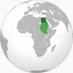
Ceded from Sudan to
Italian North Africa in 1919 |
| Date | 4 June 2010 (original upload date) |
| Source | Transferred from en.wikipedia to Commons by BomBom. |
| Author | VoodooIsland at English Wikipedia |
| Other versions |
 |
Licensing
| This work has been released into the
public domain by its author,
VoodooIsland at
English Wikipedia. This applies worldwide. In some countries this may not be legally possible; if so: VoodooIsland grants anyone the right to use this work for any purpose, without any conditions, unless such conditions are required by law. |
Original upload log
The original description page was
here. All following user names refer to en.wikipedia.
- 2010-06-04 02:46 VoodooIsland 2000×2000× (608364 bytes) '''Green''': Kingdom of Egypt<br>'''Light green''': [[Anglo-Egyptian Sudan]] [[condominium]]<br>'''Lightest green''': Ceded from Sudan to [[Italian Libya]] in [[1919]]
File history
Click on a date/time to view the file as it appeared at that time.
| Date/Time | Thumbnail | Dimensions | User | Comment | |
|---|---|---|---|---|---|
| current | 23:40, 9 July 2010 |
| 2,000 × 2,000 (594 KB) | BomBom | {{Information |Description={{en| {{legend|#336432| Kingdom of Egypt}} {{legend|#54A754| Anglo-Egyptian Sudan condominium}} {{legend|#A0FFB9|Ceded from Sudan to [[w:Itali |
File usage
The following pages on the English Wikipedia use this file (pages on other projects are not listed):
Global file usage
The following other wikis use this file:
- Usage on ar.wikipedia.org
- Usage on arz.wikipedia.org
- Usage on ast.wikipedia.org
- Usage on az.wikipedia.org
- Usage on ckb.wikipedia.org
- Usage on cs.wikipedia.org
- Usage on da.wikipedia.org
- Usage on de.wikipedia.org
- Usage on es.wikipedia.org
- Usage on eu.wikipedia.org
- Usage on fa.wikipedia.org
- Usage on fr.wikipedia.org
- Usage on he.wikipedia.org
- Usage on hu.wikipedia.org
- Usage on id.wikipedia.org
- Usage on it.wikipedia.org
- Usage on ko.wikipedia.org
- Usage on ku.wikipedia.org
- Usage on ms.wikipedia.org
- Usage on mt.wikipedia.org
- Usage on pnb.wikipedia.org
- Usage on pt.wikipedia.org
- Usage on ru.wikipedia.org
- Usage on sh.wikipedia.org
- Usage on sr.wikipedia.org
- Usage on sv.wikipedia.org
- Usage on tg.wikipedia.org
- Usage on th.wikipedia.org
- Usage on uk.wikipedia.org
View more global usage of this file.