
Size of this PNG preview of this SVG file:
800 × 353 pixels. Other resolutions:
320 × 141 pixels |
640 × 282 pixels |
1,024 × 451 pixels |
1,280 × 564 pixels |
2,560 × 1,128 pixels |
810 × 357 pixels.
Original file (SVG file, nominally 810 × 357 pixels, file size: 88 KB)
| This is a file from the
Wikimedia Commons. Information from its
description page there is shown below. Commons is a freely licensed media file repository. You can help. |
Summary
| Description |
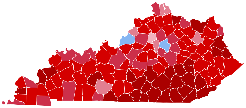
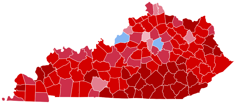
English: State election results in Kentucky, by county – presidential election 2020.
Biden—>90%
Biden—80-90%
Biden—70-80%
Biden—60-70%
Biden—50-60%
Biden—40-50%
Biden—30-40%
Trump—30-40%
Trump—40-50%
Trump—50-60%
Trump—60-70%
Trump—70-80%
Trump—80-90%
Trump—>90% |
| Date | |
| Source | Own work |
| Author | TylerKutschbach |
Licensing
I, the copyright holder of this work, hereby publish it under the following license:
This file is licensed under the
Creative Commons
Attribution-Share Alike 4.0 International license.
- You are free:
- to share – to copy, distribute and transmit the work
- to remix – to adapt the work
- Under the following conditions:
- attribution – You must give appropriate credit, provide a link to the license, and indicate if changes were made. You may do so in any reasonable manner, but not in any way that suggests the licensor endorses you or your use.
- share alike – If you remix, transform, or build upon the material, you must distribute your contributions under the same or compatible license as the original.
File history
Click on a date/time to view the file as it appeared at that time.
| Date/Time | Thumbnail | Dimensions | User | Comment | |
|---|---|---|---|---|---|
| current | 03:47, 7 July 2023 |
| 810 × 357 (88 KB) | Gordfather69 | Fixes |
| 03:41, 21 May 2023 |
 | 810 × 357 (88 KB) | Putitonamap98 | shapes | |
| 03:49, 14 January 2023 |
 | 744 × 341 (798 KB) | Putitonamap98 | shapes | |
| 06:20, 22 November 2020 |
 | 390 × 186 (26 KB) | TylerKutschbach | Reverted to version as of 04:16, 21 November 2020 (UTC) | |
| 05:12, 21 November 2020 |
 | 390 × 186 (26 KB) | TylerKutschbach | Updated Mason County. | |
| 04:16, 21 November 2020 |
 | 390 × 186 (26 KB) | TylerKutschbach | Updated map. | |
| 15:48, 10 November 2020 |
 | 390 × 186 (26 KB) | TylerKutschbach | Fixed Clay County. | |
| 03:42, 8 November 2020 |
 | 390 × 186 (26 KB) | TylerKutschbach | Uploaded own work with UploadWizard |
File usage
The following pages on the English Wikipedia use this file (pages on other projects are not listed):
Global file usage
The following other wikis use this file:
- Usage on simple.wikipedia.org