
Size of this PNG preview of this SVG file:
720 × 576 pixels. Other resolutions:
300 × 240 pixels |
600 × 480 pixels |
960 × 768 pixels |
1,280 × 1,024 pixels |
2,560 × 2,048 pixels.
Original file (SVG file, nominally 720 × 576 pixels, file size: 1.07 MB)
| This is a file from the
Wikimedia Commons. Information from its
description page there is shown below. Commons is a freely licensed media file repository. You can help. |
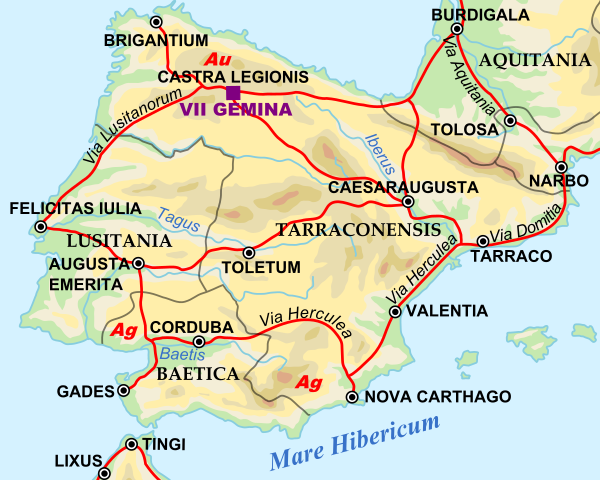
| Description | Shows Iberian peninsula in 125 including important roads, legionnaire locations and gold/silver mines. "NOTE: Barbarian names and locations as in the works of Tacitus (written ca. 100 AD)" |
| Date | |
| Source | |
| Author |
|
SVG Support
This document is in the Scalable Vector Graphic format (SVG) and requires a supported browser (Firefox, Google Chrome, Opera) or a SVG plugin for Internet Explorer and other browsers. SVG is an open source format, which means this map can be downloaded and modified/translated completely using a vector graphics editor like Adobe Illustrator or Inkscape (free) or a text editor such as Notepad.
| BLANK THUMBNAIL | View large PNG | View medium PNG | SVG Plugin for Internet Explorer and other browsers |
|---|---|---|---|
| Click here (purge cache) and then CTRL+F5 to reload. Help? | Try 1 Try 2 | Try 1 Try 2 | Adobe SVG plugin |
| Recommended browser | More Help | ||
| Firefox | List of SVG tools |
| This is a
retouched picture, which means that it has been digitally altered from its original version. Modifications: Zoomed in to Iberian peninsula. The original can be viewed here:
Roman Empire 125.svg:
|
| I, the copyright holder of this work, release this work into the
public domain. This applies worldwide. In some countries this may not be legally possible; if so: I grant anyone the right to use this work for any purpose, without any conditions, unless such conditions are required by law. |
Original upload log
This image is a derivative work of the following images:
- File:Roman_Empire_125.svg licensed with PD-user-en, PD-user-w, PD-user-w/de
Uploaded with derivativeFX
File history
Click on a date/time to view the file as it appeared at that time.
| Date/Time | Thumbnail | Dimensions | User | Comment | |
|---|---|---|---|---|---|
| current | 10:45, 29 April 2009 |
| 720 × 576 (1.07 MB) | ArdadN | update2 |
| 10:40, 29 April 2009 |
 | 720 × 576 (1.07 MB) | ArdadN | update | |
| 20:21, 28 March 2009 |
 | 720 × 576 (1.07 MB) | Malus Catulus | {{Information |Description=Shows Iberian peninsula in 125 including important roads, legionnaire locations and gold/silver mines. "NOTE: Barbarian names and locations as in the works of Tacitus (written ca. 100 AD)" |Source=*[[:File:Roman_Empire_125.svg| |
File usage
The following pages on the English Wikipedia use this file (pages on other projects are not listed):
Global file usage
The following other wikis use this file:
- Usage on arz.wikipedia.org
- Usage on ast.wikipedia.org
- Usage on bg.wikipedia.org
- Usage on bs.wikipedia.org
- Usage on el.wikipedia.org
- Usage on es.wikipedia.org
- Usage on et.wikipedia.org
- Usage on eu.wikipedia.org
- Usage on fi.wikipedia.org
- Usage on fr.wikipedia.org
- Usage on hr.wikipedia.org
- Usage on hu.wikipedia.org
- Usage on hy.wikipedia.org
- Usage on it.wikipedia.org
- Usage on ja.wikipedia.org
- Usage on ko.wikipedia.org
- Usage on la.wikipedia.org
- Usage on lv.wikipedia.org
- Usage on nl.wikipedia.org
- Usage on pt.wikiversity.org
- Usage on ru.wikipedia.org
- Usage on sh.wikipedia.org
- Usage on sl.wikipedia.org
- Usage on sv.wikipedia.org
- Usage on th.wikipedia.org
- Usage on uk.wikipedia.org
View more global usage of this file.