
Size of this PNG preview of this SVG file:
800 × 467 pixels. Other resolutions:
320 × 187 pixels |
640 × 374 pixels |
1,024 × 598 pixels |
1,280 × 747 pixels |
2,560 × 1,494 pixels |
1,052 × 614 pixels.
Original file (SVG file, nominally 1,052 × 614 pixels, file size: 2.12 MB)
| This is a file from the
Wikimedia Commons. Information from its
description page there is shown below. Commons is a freely licensed media file repository. You can help. |
Summary
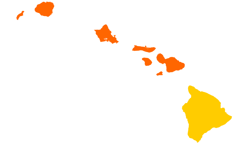
| Description | Results of the Hawaii Republican caucuses, 2012. | ||||||||
| Date | |||||||||
| Source | Own work | ||||||||
| Author | Gage | ||||||||
| Other versions |
|

.png)
-2.png)


.svg)


Licensing
| I, the copyright holder of this work, release this work into the
public domain. This applies worldwide. In some countries this may not be legally possible; if so: I grant anyone the right to use this work for any purpose, without any conditions, unless such conditions are required by law. |
File history
Click on a date/time to view the file as it appeared at that time.
| Date/Time | Thumbnail | Dimensions | User | Comment | |
|---|---|---|---|---|---|
| current | 22:50, 24 March 2024 |
| 1,052 × 614 (2.12 MB) | Putitonamap98 | shapes |
| 23:42, 4 April 2012 |
 | 274 × 160 (6 KB) | Bielsko | Reverted to version as of 22:23, 24 March 2012 Maui County: Romney not Paul wins it. Paul maybe won with provisional ballots, but they aren't officially certified, so we mustn't count it. | |
| 22:25, 24 March 2012 |
 | 274 × 160 (6 KB) | Gage | fix | |
| 22:23, 24 March 2012 |
 | 274 × 160 (6 KB) | Gage | Maui County, HI provisional ballots give Paul win | |
| 10:10, 14 March 2012 |
 | 274 × 160 (6 KB) | Gage | update | |
| 09:20, 14 March 2012 |
 | 274 × 160 (6 KB) | Gage | update | |
| 00:41, 14 March 2012 |
 | 274 × 160 (6 KB) | Gage | == {{int:filedesc}} == {{Information |Description=Results of the Hawaii Republican caucuses, 2012. |Source={{Own}} |Date=2012 March 13 |Author= Gage |other_versions={{2012 US presidential election map... |
File usage
The following pages on the English Wikipedia use this file (pages on other projects are not listed):
Global file usage
The following other wikis use this file:
- Usage on es.wikipedia.org
- Usage on it.wikipedia.org
- Usage on pt.wikipedia.org