
Size of this preview:
556 × 599 pixels. Other resolutions:
223 × 240 pixels |
445 × 480 pixels |
713 × 768 pixels |
950 × 1,024 pixels |
1,610 × 1,735 pixels.
Original file (1,610 × 1,735 pixels, file size: 523 KB, MIME type: image/png)
| This is a file from the
Wikimedia Commons. Information from its
description page there is shown below. Commons is a freely licensed media file repository. You can help. |
Summary
| Description |
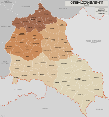
English: Administrative map of the Generalgouvernement für die besetzten polnischen Gebiete. |
| Date | |
| Source | Own work |
| Author | XrysD |
| Other versions | File:General Government for the occupied Polish territories.png |
Licensing
I, the copyright holder of this work, hereby publish it under the following licenses:
This file is licensed under the
Creative Commons
Attribution-Share Alike 3.0 Unported license.
- You are free:
- to share – to copy, distribute and transmit the work
- to remix – to adapt the work
- Under the following conditions:
- attribution – You must give appropriate credit, provide a link to the license, and indicate if changes were made. You may do so in any reasonable manner, but not in any way that suggests the licensor endorses you or your use.
- share alike – If you remix, transform, or build upon the material, you must distribute your contributions under the same or compatible license as the original.

|
Permission is granted to copy, distribute and/or modify this document under the terms of the GNU Free Documentation License, Version 1.2 or any later version published by the Free Software Foundation; with no Invariant Sections, no Front-Cover Texts, and no Back-Cover Texts. A copy of the license is included in the section entitled GNU Free Documentation License. |
You may select the license of your choice.
File history
Click on a date/time to view the file as it appeared at that time.
| Date/Time | Thumbnail | Dimensions | User | Comment | |
|---|---|---|---|---|---|
| current | 10:11, 17 October 2021 |
| 1,610 × 1,735 (523 KB) | XrysD | Incorporated typos KRUBIESZOW->HRUBIESZOW and CZORTZOW->CZORTKOW |
| 18:12, 11 October 2021 |
 | 1,610 × 1,735 (575 KB) | Kamilhrub | Czortzow → Czortkow | |
| 10:30, 6 October 2021 |
 | 1,610 × 1,735 (575 KB) | Kamilhrub | Corrected name Hrubieszow and southern borders of Bilgoraj, Hrubieszow and Zamosc districts, which didn't change after 1941 (source: Amtliches Gemeinde- und Dorfverzeichnis für das Generalgouvernement auf Grund der Summarischen Bevölkerungsbestandsaufnahme am 1. März 1943) | |
| 09:41, 8 May 2015 |
 | 1,610 × 1,735 (438 KB) | RokerHRO | optipng -o7 -i0 → 21.79% decrease | |
| 10:36, 19 April 2015 |
 | 1,610 × 1,735 (560 KB) | XrysD | Komplett neue Karte. Grundkarte: Karte des Deutschen Reiches 1:100k, Karte von Mitteleuropa 1:300k, Mapa Administracyjna Rzeczypospolitej Polska 1:300k (Quelle mapyWIG). | |
| 16:18, 27 May 2012 |
 | 2,299 × 2,280 (398 KB) | XrysD | Fixed typos | |
| 19:51, 26 May 2012 |
 | 2,299 × 2,280 (396 KB) | XrysD | Changed version to all German Language. Changed all colours to use Bartholomew set. English language version can now be found under File:General Government for the occupied Polish territories.png | |
| 19:45, 26 May 2012 |
 | 2,299 × 2,280 (396 KB) | XrysD | Changed version to all German Language. Changed all colours to use Bartholomew set. English language version can now be found under File:General Government for the occupied Polish territories.png | |
| 20:38, 23 January 2009 |
 | 2,299 × 2,280 (391 KB) | XrysD | {{Information |Description= |Source= |Date= |Author= |Permission= |other_versions= }} | |
| 19:36, 29 November 2008 |
 | 2,299 × 2,279 (367 KB) | XrysD | {{Information |Description={{en|1=Administrative map of the Generalgouvernement für die besetzten polnischen Gebiete.}} |Source=Own work by uploader |Author= XrysD |Date=29/11/2008 |Permission= |other_versions= }} <!--{{ImageUpload|full}}- |
File usage
No pages on the English Wikipedia use this file (pages on other projects are not listed).
Global file usage
The following other wikis use this file:
- Usage on ar.wikipedia.org
- Usage on ast.wikipedia.org
- Usage on ba.wikipedia.org
- Usage on be-tarask.wikipedia.org
- Usage on ca.wikipedia.org
- Usage on cs.wikipedia.org
- Usage on de.wikipedia.org
- Usage on el.wikipedia.org
- Usage on es.wikipedia.org
- Usage on fi.wikipedia.org
- Usage on fr.wikipedia.org
- Usage on fr.wiktionary.org
- Usage on gl.wikipedia.org
- Usage on hu.wikipedia.org
- Usage on it.wikipedia.org
- Usage on sh.wikipedia.org
- Usage on simple.wikipedia.org
- Usage on sr.wikipedia.org
- Usage on sv.wikipedia.org
- Usage on uk.wikipedia.org
- Usage on www.wikidata.org
- Usage on zh.wikipedia.org