
Original file (4,481 × 4,545 pixels, file size: 3.59 MB, MIME type: image/jpeg)
| This is a file from the
Wikimedia Commons. Information from its
description page there is shown below. Commons is a freely licensed media file repository. You can help. |
Summary
| Description |
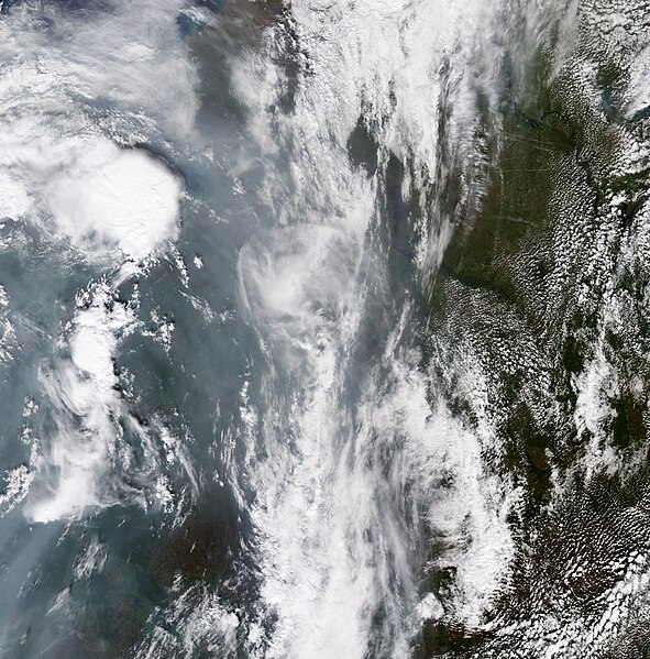
English: This is a true-colour view of far northern Russia on August 1, 2010. This image provides rare evidence that
fire
clouds can pull
smoke into the stratosphere. The circular cloud surrounded by hazy,
gray-
white smoke is a pyrocumulonimbus, a powerful
thunderstorm that forms over large fires.
Weather models and other
satellite data reveal that it formed over fires in western Russia on July 30, then drifted northward.
Fires heat the air, pushing it high into the atmosphere where it can cool and form clouds with ice crystals. The crystals conduct electricity, forming a strong, dangerous thunderstorm. Pyrocumulonimbus clouds can produce strong winds and tornadoes that can further fuel the fire’s growth. In the past decade, it has become clear that pyrocumulonimbus clouds also act like chimneys, pulling smoke into the stratosphere. Once in the stratosphere and above the weather, smoky aerosols can linger for a long time and spread around the globe. These aerosols can warm the stratosphere and cool the air below by absorbing energy from the Sun. However, this image shows one of the few pyrocumulonimbus clouds that have ever been documented, so it isn’t clear how often fires put aerosols in the stratosphere and how large an impact they have on weather and climate. |
| Date | |
| Source | NASA Earth Observatory |
| Author | Jesse Allen |
Image captured by the Moderate Resolution Imaging Spectroradiometer (MODIS) on NASA’s Aqua satellite.
Licensing
| This file is in the public domain in the United States because it was solely created by NASA. NASA copyright policy states that "NASA material is not protected by copyright unless noted". (See Template:PD-USGov, NASA copyright policy page or JPL Image Use Policy.) | ||
 |
Warnings:
|
File history
Click on a date/time to view the file as it appeared at that time.
| Date/Time | Thumbnail | Dimensions | User | Comment | |
|---|---|---|---|---|---|
| current | 08:57, 2 September 2010 |
| 4,481 × 4,545 (3.59 MB) | Originalwana | {{Information |Description={{en|1=This is a true-colour view of far northern Russia on August 1, 2010. This image provides rare evidence that fire clouds can pull smoke into the stratosphere. The circular cloud surrounded by hazy, [[gray |