Size of this preview:
448 × 600 pixels. Other resolutions:
179 × 240 pixels |
535 × 716 pixels.
Original file (535 × 716 pixels, file size: 150 KB, MIME type: image/jpeg)
| This is a file from the
Wikimedia Commons. Information from its
description page there is shown below. Commons is a freely licensed media file repository. You can help. |
Summary
| Description |
English:
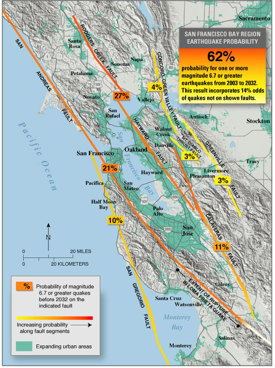
USGS seismic hazard map showing the probability of an M6.7 or greater earthquake occurring in the
San Francisco Bay Area between
2003 and
2032.
Recent (January 2008) assessments (San Jose Mercury News:
Hayward fault might be more dangerous than scientists thought ) suggest that the
Hayward, Rodgers Creek, and northern
Calaveras faults may be more likely to fail in the next few decades than previously thought (more so than is indicated on this map). |
| Source | https://pubs.usgs.gov/fs/old.2003/fs039-03/ |
| Author |
Licensing
This image is in the
public domain in the United States because it only contains materials that originally came from the
United States Geological Survey, an agency of the
United States Department of the Interior. For more information, see
the official USGS copyright policy.
|
Original upload log
The original description page was
here. All following user names refer to en.wikipedia.
- 2005-05-04 07:16 RockBandit 535×716×8 (153090 bytes) [[USGS]] seismic hazard map showing the probability of a M6.7 or greater earthquake occuring in the [[San Francisco Bay Area]] between [[2003]] and [[2032]]. {{PD-USGov-Interior-USGS}}
File history
Click on a date/time to view the file as it appeared at that time.
| Date/Time | Thumbnail | Dimensions | User | Comment | |
|---|---|---|---|---|---|
| current | 20:21, 13 May 2008 |
| 535 × 716 (150 KB) | Satipatthana | {{Information |Description={{en| en:USGS seismic hazard map showing the probability of an M6.7 or greater earthquake occurring in the en:San Francisco Bay Area between en:2003 and en:2032. Recent (January 2008) assessments (San Jose Me |
File usage
The following pages on the English Wikipedia use this file (pages on other projects are not listed):
Global file usage
The following other wikis use this file:
- Usage on ar.wikipedia.org
- Usage on de.wikipedia.org
- Usage on en.wikibooks.org
- Usage on es.wikipedia.org
- Usage on gl.wikipedia.org
- Usage on id.wikipedia.org
- Usage on it.wikibooks.org
- Usage on it.wikiversity.org
- Usage on la.wikipedia.org
- Usage on www.wikidata.org
- Usage on zh.wikipedia.org