
Size of this PNG preview of this SVG file:
800 × 554 pixels. Other resolutions:
320 × 222 pixels |
640 × 443 pixels |
1,024 × 709 pixels |
1,280 × 886 pixels |
2,560 × 1,773 pixels |
1,356 × 939 pixels.
Original file (SVG file, nominally 1,356 × 939 pixels, file size: 91 KB)
| This is a file from the
Wikimedia Commons. Information from its
description page there is shown below. Commons is a freely licensed media file repository. You can help. |
Summary
| Description |
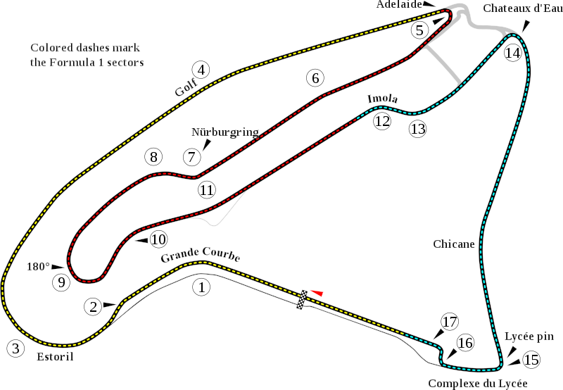
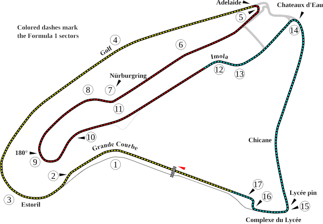
English: Track map of
w:Circuit de Nevers Magny-Cours. |
| Date | |
| Source | Own work |
| Author | Will Pittenger |
| Other versions |
|

| Camera location |
| View this and other nearby images on: OpenStreetMap |
|
|---|
Licensing
| I, the copyright holder of this work, release this work into the
public domain. This applies worldwide. In some countries this may not be legally possible; if so: I grant anyone the right to use this work for any purpose, without any conditions, unless such conditions are required by law. |
File history
Click on a date/time to view the file as it appeared at that time.
| Date/Time | Thumbnail | Dimensions | User | Comment | |
|---|---|---|---|---|---|
| current | 05:09, 13 July 2008 |
| 1,356 × 939 (91 KB) | Will Pittenger | New version gets around the text on path bug in Mediawiki by turning such text into objects. To edit the text, please use the previous version. |
| 05:06, 13 July 2008 |
 | 1,356 × 939 (67 KB) | Will Pittenger | {{Information |Description={{en|1=Track map of w:Circuit de Nevers Magny-Cours.}} |Source=Own work by uploader |Author= Will Pittenger |Date=7-13-2008 |Permission= |other_versions=<gallery>Image:Circuit de Nevers Magny-Cours.png |
File usage
The following pages on the English Wikipedia use this file (pages on other projects are not listed):
- 2003 FIA GT Magny-Cours 500km
- 2003 French Grand Prix
- 2004 FIA GT Magny-Cours 500km
- 2004 French Grand Prix
- 2004 Magny-Cours F3000 round
- 2005 FIA GT Magny-Cours Supercar 500
- 2005 FIA WTCC Race of France
- 2005 French Grand Prix
- 2005 Magny-Cours GP2 Series round
- 2005 Magny-Cours Porsche Supercup round
- 2006 French Grand Prix
- 2006 Magny-Cours GP2 Series round
- 2006 Magny-Cours Superbike World Championship round
- 2007 French Grand Prix
- 2007 Magny-Cours GP2 Series round
- 2007 Magny-Cours Superbike World Championship round
- 2008 French Grand Prix
- 2008 Magny-Cours GP2 Series round
- 2008 Magny-Cours Superbike World Championship round
- 2009 Magny-Cours Superbike World Championship round
- 2009 Magny-Cours Superleague Formula round
- 2010 Magny-Cours Superbike World Championship round
- 2010 Magny-Cours Superleague Formula round
- 2011 Magny-Cours Superbike World Championship round
- 2016 Magny-Cours Superbike World Championship round
- 2021 GT World Challenge Europe Sprint Cup Magny-Cours round
- Circuit de Nevers Magny-Cours
- FIA WTCR Race of France
- French Grand Prix
- List of FIA World Touring Car Championship circuits
- List of Formula One circuits
- List of Superbike World Championship circuits
- List of Superleague Formula circuits
- User:SmackJam/sandbox/2020 90 Minutes at Magny-Cours
- User:SmackJam/sandbox/90 Minutes at Magny-Cours
- User talk:4u1e/archive5
- User talk:4u1e/archive6
- User talk:Aecis
- User talk:Apterygial/Archive 5
- User talk:Ayrton Prost/archive 4
- User talk:Bam123456789/Archive 1
- User talk:Bam123456789/Archive 3
- User talk:Barkjon/Archive 2
- User talk:Cdhaptomos/Archive 1
- User talk:Cdhaptomos/Archive 2
- User talk:Chubbennaitor/Archive7
- User talk:Chubbennaitor/archive2
- User talk:Clyde1998/Archive/2008
- User talk:Clyde1998/Archive/2009
- User talk:Cs-wolves/Archive 3
- User talk:Cs-wolves/Archive 5
- User talk:Darth Newdar/Archive/2009
- User talk:Donnie Park/Archive 1
- User talk:Donnie Park/Archive 3
- User talk:Grahamhopgood/Archive/2009 August
- User talk:Hellboy2hell/archive2
- User talk:Hellboy2hell/archive4
- User talk:Jamesontai/Archive 7
- User talk:KaragouniS/Archive 4
- User talk:MetzMaboo/Archive/2009
- User talk:Midgrid/Archive 6
- User talk:Midgrid/Archive 9
- User talk:NapHit/Archive 1
- User talk:NapHit/Archive 4
- User talk:Paste/Archive 3
- User talk:PodPedia/Archive/2009
- User talk:Readro/Archive 3
- User talk:Readro/Archive 4
- User talk:Sage Callahan/Archive 1
- User talk:Sage Callahan/Archive 2
- User talk:Schumi555/archive3
- User talk:Spenalzo/Archive/2008
- User talk:Spenalzo/Archive/2009
- User talk:Sporti/Archive 1
- User talk:Ste900R/Archive 3
- User talk:The359/Archive 4
- User talk:The359/Archive 5
- User talk:Thelb4/Archive 5
- User talk:Thelb4/Archive 6
- User talk:Trekphiler/Archive 2
- User talk:Typ932/Archive 3
- User talk:Typ932/Archive 6
- User talk:WilliamF1two/March 2009 to April 2010
- Wikipedia:WikiProject Formula One/Newsletter/200808
- Wikipedia:WikiProject Formula One/Newsletter/200907
- Portal:Formula One/Selected article
- Portal:Formula One/Selected article/16
- Portal:Formula One/Selected article/18
Global file usage
The following other wikis use this file:
- Usage on af.wikipedia.org
- Usage on ar.wikipedia.org
- Usage on ast.wikipedia.org
- Usage on bg.wikipedia.org
- Usage on bn.wikipedia.org
- Usage on br.wikipedia.org
- Usage on ca.wikipedia.org
- Usage on cs.wikipedia.org
- Usage on de.wikipedia.org
View more global usage of this file.