Size of this preview:
475 × 599 pixels. Other resolutions:
190 × 240 pixels |
381 × 480 pixels |
808 × 1,019 pixels.
Original file (808 × 1,019 pixels, file size: 1.15 MB, MIME type: image/png)
| This is a file from the
Wikimedia Commons. Information from its
description page there is shown below. Commons is a freely licensed media file repository. You can help. |
Summary
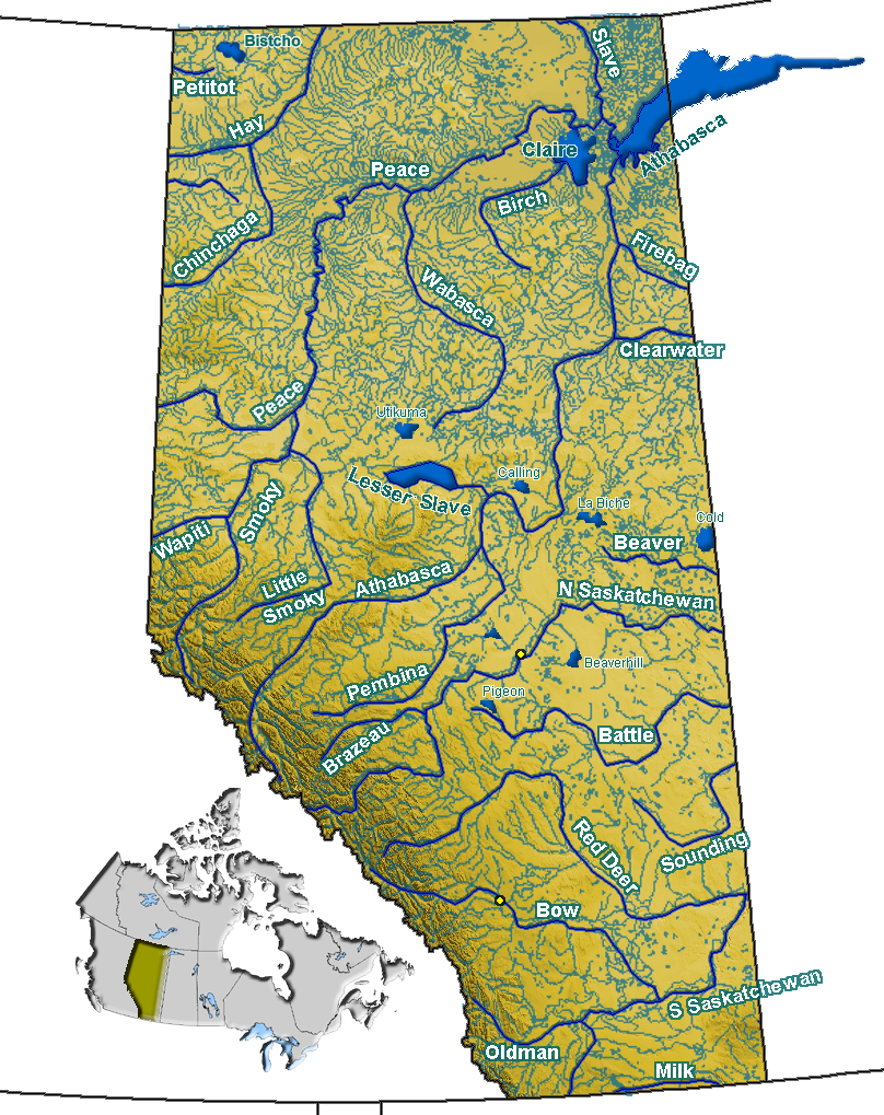
| Description | Rivers in Alberta, Canada |
| Date | |
| Source | GIS data |
| Author | Qyd |
| Permission ( Reusing this file) |
All |
Licensing
| I, the copyright holder of this work, release this work into the
public domain. This applies worldwide. In some countries this may not be legally possible; if so: I grant anyone the right to use this work for any purpose, without any conditions, unless such conditions are required by law. |
File history
Click on a date/time to view the file as it appeared at that time.
| Date/Time | Thumbnail | Dimensions | User | Comment | |
|---|---|---|---|---|---|
| current | 18:30, 27 November 2007 |
| 808 × 1,019 (1.15 MB) | Qyd | fix lake name |
| 23:43, 9 September 2006 |
 | 808 × 1,019 (1.15 MB) | Qyd | add some lakes, remove wrong rivers | |
| 20:43, 29 August 2006 |
 | 808 × 1,019 (1.16 MB) | Qyd | emphase lake, creeks color | |
| 19:39, 29 August 2006 |
 | 808 × 1,019 (1.15 MB) | Qyd | lakes | |
| 02:14, 22 August 2006 |
 | 808 × 1,019 (1.17 MB) | Qyd | add names | |
| 01:41, 22 August 2006 |
 | 808 × 1,128 (1.16 MB) | Qyd | {{Information |Description=Rivers in Alberta, Canada |Source=USGS data |Date=Aug 2006 |Author= Qyd |Permission=All |other_versions= }} Category:Maps of Alberta |
File usage
More than 100 pages use this file. The following list shows the first 100 pages that use this file only. A full list is available.
- Abraham Lake
- Athabasca Falls
- Athabasca River
- Barrier Lake
- Battle Creek (Milk River tributary)
- Battle River
- Beaver River (Canada)
- Beaverhill Lake
- Bistcho Lake
- Bonnie Lake (Alberta)
- Bow Falls
- Bow Lake (Alberta)
- Bow River
- Brazeau River
- Brûlé Lake (Alberta)
- Buffalo Lake (Alberta)
- Calling Lake
- Cardinal Lake
- Chester Lake (Alberta)
- Chestermere Lake
- Chinchaga River
- Clearwater River (Alberta)
- Clearwater River (Saskatchewan)
- Cold Lake (Alberta)
- Crowfoot Glacier
- Crowsnest River
- Elbow Falls
- Elbow Lake (Alberta)
- Elbow River
- Elkwater Lake (Alberta)
- Firebag River
- Geography of Alberta
- Glenmore Reservoir
- Hay River (Canada)
- Headwall Lakes
- Hector Lake
- Hidden Lake (Alberta)
- Highwood River
- Howse River
- Jessie Lake
- Johnston Creek (Alberta)
- Kananaskis River
- Lac Beauvert
- Lac Ste. Anne (Alberta)
- Lac la Biche (Alberta)
- Lake Agnes (Alberta)
- Lake Athabasca
- Lake Claire (Alberta)
- Lake Minnewanka
- Lesser Slave Lake
- Lesser Slave River
- List of lakes of Alberta
- List of rivers of Alberta
- Little Smoky River
- Lower Kananaskis Lake
- Maligne Lake
- Medicine Lake (Alberta)
- Milk River (Alberta–Montana)
- Mill Creek Ravine
- Mistaya River
- Moraine Lake
- Mud Lake (Alberta)
- North Saskatchewan River
- Oldman River
- Peace River
- Peace–Athabasca Delta
- Pembina River (Alberta)
- Petitot River
- Peyto Lake
- Pigeon Lake (Alberta)
- Pinehurst Lake
- Pipestone Creek
- Primrose Lake
- Pyramid Lake (Alberta)
- Red Deer Lake (Alberta)
- Red Deer River
- Sheep River (Alberta)
- Skeleton Lake (Alberta)
- Slave River
- Smoky River
- South Saskatchewan River
- Spray River
- St. Mary River (Alberta–Montana)
- Sturgeon Lake (Alberta)
- Sturgeon River (Alberta)
- Sunwapta Falls
- Sunwapta River
- Sylvan Lake (Alberta)
- Upper Kananaskis Lake
- Utikuma Lake
- Vermilion Lakes
- Vermilion River (Alberta)
- Wabamun Lake
- Wabasca River
- Wapiti River
- Waterton Lake
- Winefred Lake
- Zama Lake
- User:Qyd/Maps
- Template:Alberta rivers and lakes
View more links to this file.
Global file usage
The following other wikis use this file:
- Usage on arz.wikipedia.org
- Usage on bg.wikipedia.org
- Usage on ca.wikipedia.org
- Usage on ceb.wikipedia.org
- Usage on cs.wikipedia.org
- Usage on de.wikipedia.org
- Usage on eo.wikipedia.org
- Usage on es.wikipedia.org
- Usage on fa.wikipedia.org
- آلبرتا
- آبنگاری
- آبشار
- رود ساسکاچوان شمالی
- یخچال طبیعی
- مخزن سد
- آبشار پانتر
- آبشار باو
- آبشار کرسنت
- آبشار کرایپت
- آبشار البو
- هی ریور (کانادا)
- بتل ریور
- اسموکی ریور
- بیور ریور (کانادا)
- برازو ریور
- رود اتبسکا
- رود پیس
- رود میلک (آلبرتا–مونتانا)
- رود اولدمن
- رودخانه بو
- دریاچه بریر
- الگو:رودها و دریاچههای آلبرتا
- رود اسلیو
- دریاچه لوئیز (آلبرتا)
- دریاچه آتاباسکا
- دریاچه مالیگن
- Usage on fr.wikipedia.org
View more global usage of this file.