
Size of this preview:
472 × 600 pixels. Other resolutions:
189 × 240 pixels |
377 × 480 pixels |
604 × 768 pixels |
805 × 1,024 pixels |
1,611 × 2,048 pixels |
4,720 × 6,000 pixels.
Original file (4,720 × 6,000 pixels, file size: 8.7 MB, MIME type: image/jpeg)
| This is a file from the
Wikimedia Commons. Information from its
description page there is shown below. Commons is a freely licensed media file repository. You can help. |
| Artist | ||||||
| Title |
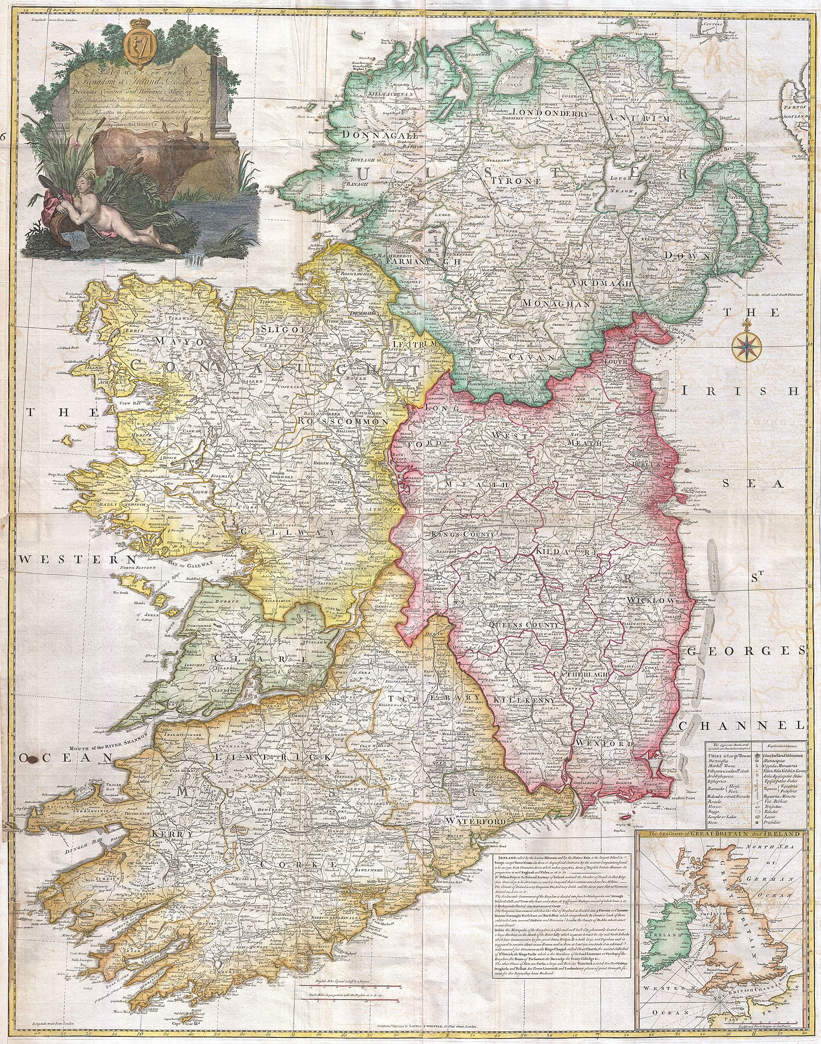
A map of the Kingdom of Ireland, divided into provinces, counties and baronies. Southern section. Shewing the archbishopricks, bishopricks, cities, boroughs, market towns, villages, barracks, mountains, lakes, bays, rivers, bridges, ferries, passes, also the great, the branch & the by post roads together with the inland navigation, by J. Rocque, Chorographer to His Majesty. |
|||||
| Description |
English: An absolutely stunning and monumental 1794 wall map of Ireland by Jean Rocque. Covers Ireland in full with extraordinary detail throughout. Notes every town, hamlet, bishopric, country, forest, castle swam and road. Even offers some offshore detail with regard to the shoals in Georges Channel. In inset map in the lower right quadrant shows Ireland in the context of the British Isles. An elaborate title cartouche in the upper left quadrant shows the Irish Harp over two pensive bovines and a demurely positioned unclothed maiden. Published by Laurie and Whittle as plate nos. 9-10 in the 1797 edition of Thomas Kitchin's General Atlas . |
|||||
| Date | 1794 (dated) | |||||
| Dimensions | height: 50 in (127 cm); width: 38 in (96.5 cm) | |||||
| Accession number |
Geographicus link:
Ireland2-rocque-1794 |
|||||
| Source/Photographer |
Kitchin, Thomas, Kitchin's General Atlas, describing the Whole Universe: being a complete collection of the most approved maps extant; corrected with the greatest care, and augmented from the last edition of D'Anville and Robert with many improvements by other eminent geographers, engraved on Sixty-Two plates, comprising Thirty Seven maps., Laurie & Whittle, London, 1797.
|
|||||
| Permission ( Reusing this file) |
|
|||||
| Other versions | ||||||

File history
Click on a date/time to view the file as it appeared at that time.
| Date/Time | Thumbnail | Dimensions | User | Comment | |
|---|---|---|---|---|---|
| current | 04:22, 23 March 2011 |
| 4,720 × 6,000 (8.7 MB) | BotMultichillT | {{subst:User:Multichill/Geographicus |link=http://www.geographicus.com/P/AntiqueMap/Ireland2-rocque-1794 |product_name=1794 Rocque Wall Map of Ireland |map_title=A map of the Kingdom of Ireland, divided into provinces, counties and baronies. Southern sect |
File usage
The following pages on the English Wikipedia use this file (pages on other projects are not listed):
Global file usage
The following other wikis use this file:
- Usage on no.wikipedia.org