| F Line | |
|---|---|
| F | |
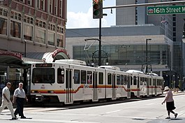
 F Line at 16th & California station | |
| Overview | |
| Status | Discontinued |
| Owner | Regional Transportation District |
| Locale | Denver metropolitan area |
| Termini | |
| Stations | 21 |
| Service | |
| Type | Light rail |
| System | RTD Rail |
| Operator(s) | Regional Transportation District |
| History | |
| Opened | November 17, 2006 |
| Closed | September 20, 2020 |
| Technical | |
| Track gauge | 4 ft 8+1⁄2 in (1,435 mm) standard gauge |
| Electrification | Overhead line, 750 V DC |
The F Line was a light rail line, part of the rail system operated by the Regional Transportation District in the Denver-Aurora Metropolitan Area in Colorado.
Route
The F Line's northern terminus is at 18th Street in downtown Denver. It shares track with the D Line from 18th Street to I-25 & Broadway, then runs along the Southeast Corridor to Lone Tree. [1]
On September 20, 2020, Regional Transportation District suspended the F Line due to the ongoing coronavirus pandemic. [2] The line never returned to service and was officially eliminated ahead of the January 2023 service change. [3]
Stations
| Station | Municipality | Opened | Major connections & notes |
|---|---|---|---|
|
18th & California (northbound) 18th & Stout (southbound) |
Denver | October 8, 1994 |
|
|
16th & California (northbound) 16th & Stout (southbound) |
| ||
|
14th & California (northbound) 14th & Stout (southbound) |
October 8, 1994 | Closed November 27, 2004 | |
| Theatre District–Convention Center | November 28, 2004 |
| |
| Colfax at Auraria | October 8, 1994 |
| |
| 10th & Osage |
| ||
| Alameda |
Park and ride: 240 spaces | ||
| I-25 & Broadway |
Park and ride: 1,248 spaces | ||
| Louisiana–Pearl | November 17, 2006 |
| |
| University of Denver |
Park and ride: 540 spaces | ||
| Colorado |
Park and ride: 363 spaces | ||
| Yale |
Park and ride: 129 spaces | ||
| Southmoor |
Park and ride: 788 spaces | ||
| Belleview |
Park and ride: 817 spaces | ||
| Orchard | Greenwood Village |
Park and ride: 48 spaces | |
| Arapahoe at Village Center |
Park and ride: 817 spaces | ||
| Dry Creek | Centennial |
Park and ride: 235 spaces | |
| County Line | Lone Tree |
Park and ride: 388 spaces | |
| Lincoln |
Park and ride: 1,734 spaces | ||
| Sky Ridge | May 17, 2019 |
| |
| Lone Tree City Center |
| ||
| RidgeGate Parkway |
Park and ride: 1,300 spaces |
FasTracks
The 2004 voter-approved FasTracks initiative included the Southeast Corridor extension for the E and F Line, which extended the lines by 2.3 mi (3.70 km) to southern Lone Tree. The extension cost $223 million to construct and was opened on May 17, 2019. [4] It included three new stations, Sky Ridge, Lone Tree City Center, and RidgeGate Parkway, the latter with a 2,000-stall parking facility. [5]
References
- ^ "RTD – Light Rail System Map". Regional Transportation District. Archived from the original on June 10, 2014. Retrieved June 2, 2014.
- ^ "Combined September and COVID-19".
- ^ Murray, Jon (December 14, 2022). "RTD is officially killing its C and F lines after suspending them during the pandemic". The Denver Post. Retrieved December 16, 2022.
- ^ Rubino, Joe (May 15, 2019). "RTD's newest line in southeast Denver metro will power development for years to come". The Denver Post. Retrieved May 17, 2019.
- ^ Aguilar, John (January 25, 2019). "Light-rail extension into Lone Tree set to start passenger service May 19". The Denver Post. Retrieved May 17, 2019.
External links
- "RTD F Line Schedule". Archived from the original on January 23, 2016.
