| Ernesto Tornquist Provincial Park | |
|---|---|
| Parque Provincial Ernesto Tornquist | |
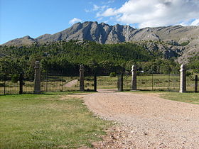
 Cerro Ventana entrance | |
| Location | Buenos Aires Province, Argentina |
| Nearest city | Sierra de La Ventana |
| Coordinates | 38°03′S 62°02′W / 38.050°S 62.033°W |
| Area | 6,718 ha (67.18 km2; 25.94 sq mi) |
| Established | April 23, 1958 [1] |
| Parque Provincial Ernesto Tornquist | |
Ernesto Tornquist Provincial Park ( Spanish: Parque Provincial Ernesto Tornquist) is a provincial protected area in the south of Buenos Aires Province, mid-eastern Argentina. Established on 23 April 1958, [1] it covers a small area of the Ventania System. [2]
References
- ^ a b Decreto No. 5421/1958 de la Provincia de Buenos Aires; prom.: 23 de abril de 1958
- ^ "Ernesto Tornquist Provincial Park". Welcome Argentina. Retrieved 7 September 2012.
External links
-
 Media related to
Parque Provincial Ernesto Tornquist at Wikimedia Commons
 - Parque Provincial Ernesto Tornquist (in Spanish)
