Erdahl | |
|---|---|
 Erdahl  Erdahl | |
| Coordinates: 45°59′31″N 95°49′04″W / 45.99194°N 95.81778°W | |
| Country | United States |
| State | Minnesota |
| County | Grant |
| Elevation | 1,266 ft (386 m) |
| Time zone | UTC-6 ( Central (CST)) |
| • Summer ( DST) | UTC-5 (CDT) |
| Area code | 218 |
| GNIS feature ID | 643390 [1] |
Erdahl is an unincorporated community in Erdahl Township, Grant County, Minnesota, United States. [1] The community is located between Evansville and Elbow Lake on Minnesota State Highway 79. [2]
History
Erdahl was platted in 1887. [3] A post office was established at Erdahl in 1883, and remained in operation until 1954. [4]
References
- ^ a b "Erdahl, Minnesota". Geographic Names Information System. United States Geological Survey, United States Department of the Interior.
- ^ Minnesota Department of Transportation-Grant County
- ^ Upham, Warren (1920). Minnesota Geographic Names: Their Origin and Historic Significance. Minnesota Historical Society. p. 214.
- ^ "Grant County". Jim Forte Postal History. Archived from the original on June 19, 2015. Retrieved June 18, 2015.
Further reading
- Rand McNally Road Atlas - 2007 edition - Minnesota entry
- Official State of Minnesota Highway Map - 2007/2008 edition
Municipalities and communities of
Grant County, Minnesota, United States | ||
|---|---|---|
| Cities | 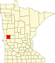 | |
| Townships | ||
|
Unincorporated communities | ||
| Former communities | ||
| Footnotes | ‡This populated place also has portions in an adjacent county or counties | |