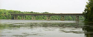
Enfield-Suffield Veterans Bridge | |
|---|---|
 | |
| Coordinates | 41°59′23″N 72°36′13″W / 41.98972°N 72.60361°W |
| Carries | |
| Crosses | Connecticut River |
| Locale | Enfield, Connecticut and Suffield, Connecticut |
| Maintained by | ConnDOT |
| Characteristics | |
| Design | Steel plate girder bridge |
| History | |
| Construction end | 1966 [1] |
| Opened | 1966 |
| Location | |
|
| |
The Enfield–Suffield Veterans Bridge, commonly known in either town as the Enfield Bridge or Suffield Bridge, is the main traffic crossing that connects the towns of Enfield and Suffield, Connecticut over the Connecticut River. It carries Route 190 as well as the Windsor Locks Canal State Park Trail across the river. [2]
See also
External links and references
- ^ Enfield-Suffield Veterans Bridge at Structurae
- ^ Protection, Department of Environmental. "DEEP: Windsor Locks Canal State Park Trail". www.ct.gov. Retrieved 2016-09-28.
Categories:
- Bridges over the Connecticut River
- Enfield, Connecticut
- Suffield, Connecticut
- Bridges completed in 1966
- Bridges in Hartford County, Connecticut
- Road bridges in Connecticut
- Box girder bridges in the United States
- Steel bridges in the United States
- Northeastern United States road stubs
- Connecticut transportation stubs
- Northeastern United States bridge (structure) stubs
- Connecticut building and structure stubs