PhotosLocation


Ellerhoop Latitude and Longitude:

53°43′39″N 9°46′14″E / 53.72750°N 9.77056°E / 53.72750; 9.77056
From Wikipedia, the free encyclopedia
Ellerhoop
Coat of arms of Ellerhoop
Location of Ellerhoop within Pinneberg district
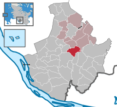
Appen Barmstedt Bevern Bilsen Bokel Bokholt-Hanredder Bönningstedt Borstel-Hohenraden Brande-Hörnerkirchen Bullenkuhlen Ellerbek Ellerhoop Elmshorn Groß Nordende Groß Offenseth-Aspern Halstenbek Haselau Hasloh Heede Heidgraben Heist Heligoland Hemdingen Hetlingen Holm Klein Nordende Klein Offenseth-Sparrieshoop Kölln-Reisiek Kummerfeld Langeln Lutzhorn Moorrege Neuendeich Osterhorn Pinneberg Prisdorf Quickborn Raa-Besenbek Rellingen Schenefeld Seester Seestermühe Seeth-Ekholt Tangstedt Tornesch Uetersen Wedel Westerhorn Haseldorf Schleswig-Holstein Hamburg Lower Saxony Segeberg Steinburg Elbe
Ellerhoop is located in Germany
Ellerhoop
Ellerhoop
Ellerhoop is located in Schleswig-Holstein
Ellerhoop
Ellerhoop
Coordinates: 53°43′39″N 9°46′14″E / 53.72750°N 9.77056°E / 53.72750; 9.77056
Country Germany
State Schleswig-Holstein
District Pinneberg
Municipal assoc. Rantzau
Government
 •  MayorWiebke Uhl ( CDU)
Area
 • Total10.8 km2 (4.2 sq mi)
Elevation
11 m (36 ft)
Population
 (2022-12-31) [1]
 • Total1,537
 • Density140/km2 (370/sq mi)
Time zone UTC+01:00 ( CET)
 • Summer ( DST) UTC+02:00 ( CEST)
Postal codes
25373
Dialling codes04120
Vehicle registrationPI
Website www.ellerhoop.de

Ellerhoop is a municipality in the district of Pinneberg in Schleswig Holstein, Germany. It is twinned with the village of Hurst Green, East Sussex, UK.

Geography

Ellerhoop is situated to the north of Hamburg, close to the A23 Autobahn.

Points of interest

References

  1. ^ "Bevölkerung der Gemeinden in Schleswig-Holstein 4. Quartal 2022" (XLS) (in German). Statistisches Amt für Hamburg und Schleswig-Holstein.