You can help expand this article with text translated from
the corresponding article in Spanish. (July 2009) Click [show] for important translation instructions.
|
El Atazar | |
|---|---|
 El Atazar. | |
 Flag  Seal | |
_mapa.svg) Municipal location within the Community of Madrid. | |
| Country | |
| Autonomous community | Community of Madrid |
| Area | |
| • Total | 11.41 sq mi (29.55 km2) |
| Population (2018)
[1] | |
| • Total | 93 |
| Time zone | UTC+1 ( CET) |
| • Summer ( DST) | UTC+2 ( CEST) |
El Atazar (Spanish pronunciation: [el ataˈθaɾ]) is a municipality of the autonomous community of Madrid in central Spain. It has a population of 102 inhabitants (INE, 2011).
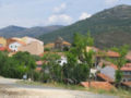
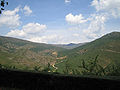
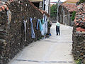
Gallery
-
-
-
 Santa Catalina Church
 -
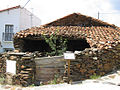 Traditional house
 -

-
 Traditional house


.jpg)
Public transport system
El Atazar has only one bus line, and it doesn’t connect the village with Madrid. This line is:
Line 913: Torrelaguna-El Atazar
References
- ^ Municipal Register of Spain 2018. National Statistics Institute.
40°56′N 3°28′W / 40.933°N 3.467°W
|
| This article about a location in the Community of Madrid, Spain is a stub. You can help Wikipedia by expanding it. |